1900s (20th Century) Maps of Franklin, Texas
Explore 7 historic maps of Franklin from the 1900s (20th Century). These maps offer a rare glimpse into what life looked like during the 1900s — showing old roads, neighborhoods, homes, and landmarks that have changed or disappeared over time.
Whether you're researching your family's past, planning a metal detecting trip, or studying how Franklin's landscape evolved across the 1900s, these high-resolution maps are a powerful tool for exploring the history of this region.
- Focus on a specific era: All maps on this page are from the 1900s, giving you a focused view of this time period.
- See what’s changed: Compare century-old streets, trails, and buildings to today's modern landscape using overlays and satellite layers.
- Research with precision: Use these maps for genealogy, historical research, land use analysis, or educational projects.
- View, download, or print: Maps are fully viewable online in high resolution, and can be downloaded or printed for your own records.
Start exploring Franklin's history through authentic maps from the 1900s. This is your window into the past.
Franklin, TX maps
(7)- 1927 Map of Marquez
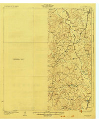 1927 Marquez1927 Print · USGSThe Leon and Robertson county border in the 1920s was a landscape of small schools and river-bottom bottomlands centered on the Marquez settlement. Genealogists can trace family roots at Camp Creek Cemetery or locate old schoolhouses like Dolly School and Blue Grove School.2 unique versions available
 - 1930 Map of Marquez
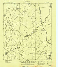 1930 Marquez1930 Print · USGSRobertson and Leon counties are mapped here at the height of the steam-rail era. Genealogists can trace family footprints through rural post offices like Bald Prairie P.O. and community anchors like Holly Church and James School.
 - 1954 Map of Waco, 1964 Print
 1954 Waco1964 Print · USGSCentral Texas during the mid-fifties shows a landscape defined by the expansion of Fort Hood Military Reservation and the Brazos river system. Trace the rail lines and early airfields like James Connally Air Force Base and settlements like Temple or McGregor.2 unique versions available
 - 1955 Map of Waco
 1955 Waco1955 Print · USGSCentral Texas at the peak of the Cold War reveals a landscape defined by military expansion and major water projects. Researchers can trace the footprints of Fort Hood, the waters of Lake Waco, and regional hubs like Temple or Mexia.
 - 1962 Map of Owensville, 1964 Print
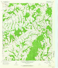 1962 Owensville1964 Print · USGSIn the heart of Robertson County during the early sixties, this map captures the dispersed settlements and family burial grounds of central Texas. Genealogists can locate Anderson Cem, Owensville Cem, and the rail corridor of the Missouri Pacific.2 unique versions available
 - 1965 Map of Franklin, 1968 Print
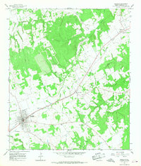 1965 Franklin1968 Print · USGSRobertson County in the mid-sixties centers on the railroad economy of Franklin and its neighboring rural settlements. Genealogists and local historians can trace the foundations of New Baden and Easterly, or locate family sites at New Baden Cem and Mt Pleasant Ch.2 unique versions available
 - 1985 Map of Marlin
 1985 Marlin1985 Print · USGSMid-century Texas agriculture and transit converge here during the mid-1980s, centered on the Brazos River corridor. Genealogists can locate family sites near Tidwell Prairie or trace the Missouri Pacific RR through Bremond and Kosse.2 unique versions available
End of results
Showing maps 1-7 of 7
Top cities near Franklin
- Hearne historical maps
- Calvert historical maps
- Bremond historical maps
- Marquez historical maps
- Kurten historical maps
Frequently asked questions
- What are the different types of historical maps available for Franklin?
- What is the oldest map of Franklin?
- Where can I purchase historical maps of Franklin for my home or office?
- Where can I download high-res historical maps of Franklin?
- Are there historical topographic maps available for Franklin?
- Is there historical aerial imagery available for Franklin?
- Where are historical maps of Franklin sourced from?