1920s Maps of San Patricio County, Texas
Explore 6 historic maps of San Patricio County from the 1920s. These maps offer a rare glimpse into what life looked like during the 1920s — showing old roads, neighborhoods, homes, and landmarks that have changed or disappeared over time.
Whether you're researching your family's past, planning a metal detecting trip, or studying how San Patricio County's landscape evolved across the 1920s, these high-resolution maps are a powerful tool for exploring the history of this region.
- Focus on a specific era: All maps on this page are from the 1920s, giving you a focused view of this time period.
- See what’s changed: Compare century-old streets, trails, and buildings to today's modern landscape using overlays and satellite layers.
- Research with precision: Use these maps for genealogy, historical research, land use analysis, or educational projects.
- View, download, or print: Maps are fully viewable online in high resolution, and can be downloaded or printed for your own records.
Start exploring San Patricio County's history through authentic maps from the 1920s. This is your window into the past.
San Patricio County, TX maps
(6)- 1925 Map of Mathis No. 2
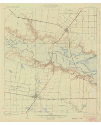
 1925 Mathis No. 21925 Print · USGSThe Nueces River valley in the mid-1920s is captured here just as aerial photography began to transform mapping. Researchers can trace the San Antonio Uvalde and Gulf railroad through old Dinero or follow the historic Old Spanish Trail.
 - 1925 Map of Robstown
 1925 Robstown1925 Print · USGSCoastal Texas near the Nueces River delta was a landscape of rail junctions and riverine wetlands during the mid-1920s. Genealogists can locate family landmarks like Ward 1 School or trace the early development of Robstown and Nuecestown.3 unique versions available
 - 1925 Map of Aransas Pass
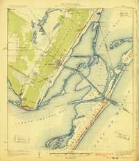 1925 Aransas Pass1925 Print · USGSThe Texas Gulf Coast comes to life in the mid-1920s, showing the early railroad developments and barrier island geography of the coastal bend. Trace the original footprints of Aransas Pass, the Aransas Pass Lighthouse, and local landmarks like Mc Campbell School.3 unique versions available
 - 1925 Map of Mathis No. 3
 1925 Mathis No. 31925 Print · USGSSouth Texas ranching country and the winding banks of the river come alive in this mid-twenties survey of the Live Oak and Jim Wells county line. Genealogy researchers can trace the early footprints of Lagarto and Sandia near the Nueces River.
 - 1925 Map of Corpus Christi, 1949 Print
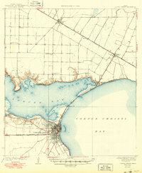 1925 Corpus Christi1949 Print · USGSCorpus Christi and the surrounding coastal plains are captured here in the 1920s, showing the early rail-and-port network of the Texas coast. Researchers can trace rural school locations like Sodville School and early industry at the West Portland Gin.
 - 1927 Map of Mathis
 1927 Mathis1927 Print · USGSSouth Texas at the height of the railroad era reveals a landscape of cattle-ranching hubs and river crossings. Genealogists can trace family connections to rural settlements like Lagarto and Sandia, or follow the path of the old Alice and Beeville Road.2 unique versions available
End of results
Showing maps 1-6 of 6
Top cities of San Patricio County
- Ingleside historical maps
- Sinton historical maps
- Mathis historical maps
- Taft historical maps
- Odem historical maps
- Gregory historical maps
See more
Frequently asked questions
- What are the different types of historical maps available for San Patricio County?
- What is the oldest map of San Patricio County?
- Where can I purchase historical maps of San Patricio County for my home or office?
- Where can I download high-res historical maps of San Patricio County?
- Are there historical topographic maps available for San Patricio County?
- Is there historical aerial imagery available for San Patricio County?
- Where are historical maps of San Patricio County sourced from?