1960s Maps of Schertz, Texas
Explore 3 historic maps of Schertz from the 1960s. These maps offer a rare glimpse into what life looked like during the 1960s — showing old roads, neighborhoods, homes, and landmarks that have changed or disappeared over time.
Whether you're researching your family's past, planning a metal detecting trip, or studying how Schertz's landscape evolved across the 1960s, these high-resolution maps are a powerful tool for exploring the history of this region.
- Focus on a specific era: All maps on this page are from the 1960s, giving you a focused view of this time period.
- See what’s changed: Compare century-old streets, trails, and buildings to today's modern landscape using overlays and satellite layers.
- Research with precision: Use these maps for genealogy, historical research, land use analysis, or educational projects.
- View, download, or print: Maps are fully viewable online in high resolution, and can be downloaded or printed for your own records.
Start exploring Schertz's history through authentic maps from the 1960s. This is your window into the past.
Schertz, TX maps
(3)- 1967 Map of Martinez, 1969 Print
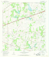 1967 Martinez1969 Print · USGSBexar County in the late sixties shows a landscape of steady rural growth and evolving water management projects. Researchers can trace family history through numerous landmarks like St Jerome Ch, Mount Olive Cem, and the community of China Grove.2 unique versions available
 - 1967 Map of Bat Cave, 1969 Print
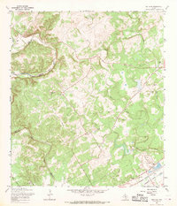 1967 Bat Cave1969 Print · USGSThe Comal County hill country comes to life in the late 1960s, showing the intersection of rail history and natural wonders. Genealogists can locate family sites like Hillert Cem and Kruetler Cem near the rail junction at Ogden.2 unique versions available
 - 1967 Map of Schertz, 1970 Print
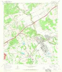 1967 Schertz1970 Print · USGSBexar and Guadalupe counties are captured in a period of rapid suburban growth in the late sixties. Genealogists can trace family names at Davenport Cem and Wheeler Cem while exploring the layout of Randolph Air Force Base.2 unique versions available
End of results
Showing maps 1-3 of 3
Top cities near Schertz
- San Antonio historical maps
- New Braunfels historical maps
- Seguin historical maps
- Universal City historical maps
- Converse historical maps
- Live Oak historical maps
See more
Top neighborhoods of Schertz
Frequently asked questions
- What are the different types of historical maps available for Schertz?
- What is the oldest map of Schertz?
- Where can I purchase historical maps of Schertz for my home or office?
- Where can I download high-res historical maps of Schertz?
- Are there historical topographic maps available for Schertz?
- Is there historical aerial imagery available for Schertz?
- Where are historical maps of Schertz sourced from?