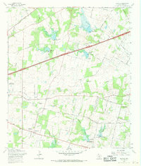
1967 Map of Martinez
USGS Topo · Published 1969About this map
The Southern Pacific railroad and an old railroad grade trace the development of eastern Bexar County on this mid-century survey. While the area maintains a predominantly agricultural and rural character, the landscape is increasingly defined by water management projects along Martinez Creek and Calaveras Creek, marked by a series of dams such as Martinez Creek Dam No 1 and Calaveras Creek Dam No 7. Small community hubs like China Grove and Saint Hedwig anchor the local road network, which includes family-named routes like Kiefer Road and Rakowitz Road. Military and recreational sites provide further regional context, ranging from the Martindale Army Airfield (National Guard) to the San Antonio Raceway. Local genealogy is well-supported by numerous landmarks, including St Jerome Ch and the Gates of Heaven Memorial Cem.
Find a feature on this map
55 named features on this map. Tap any name to fly to it.
Don’t see what you’re looking for? This feature index may not catch every label — zoom into the map to look around manually.
Map Details
Editions of this 1967 Martinez Map
2 editions found
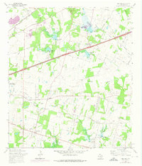
Other maps of this area

1927 · New Braunfels
USGS Topo · 1:62,500

1953 · Schertz
USGS Topo · 1:24,000

1953 · San Antonio East
USGS Topo · 1:24,000

1953 · Longhorn
USGS Topo · 1:24,000

1953 · Elmendorf
USGS Topo · 1:24,000

1953 · Southton
USGS Topo · 1:24,000

1953 · Martinez
USGS Topo · 1:24,000

1954 · San Antonio
USGS Topo · 1:250,000

1957 · San Antonio
USGS Topo · 1:250,000

1958 · Marion
USGS Topo · 1:24,000