1960s Maps of Somervell County, Texas
Explore 10 historic maps of Somervell County from the 1960s. These maps offer a rare glimpse into what life looked like during the 1960s — showing old roads, neighborhoods, homes, and landmarks that have changed or disappeared over time.
Whether you're researching your family's past, planning a metal detecting trip, or studying how Somervell County's landscape evolved across the 1960s, these high-resolution maps are a powerful tool for exploring the history of this region.
- Focus on a specific era: All maps on this page are from the 1960s, giving you a focused view of this time period.
- See what’s changed: Compare century-old streets, trails, and buildings to today's modern landscape using overlays and satellite layers.
- Research with precision: Use these maps for genealogy, historical research, land use analysis, or educational projects.
- View, download, or print: Maps are fully viewable online in high resolution, and can be downloaded or printed for your own records.
Start exploring Somervell County's history through authentic maps from the 1960s. This is your window into the past.
Somervell County, TX maps
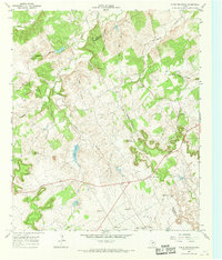
(10)- 1961 Map of Hill City, 1963 Print
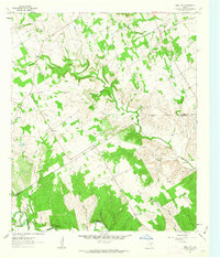 1961 Hill City1963 Print · USGSCrossing the Hood and Somervell county line in the early sixties, this landscape shows a network of family farms and rural outposts. Researchers can locate the Mt Pleasant Cemetery, the Neri schoolhouse, and the Cedar Brake Girl Scout Camp along the Paluxy River.3 unique versions available
 - 1961 Map of Nemo, 1963 Print
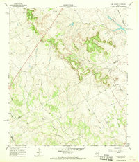
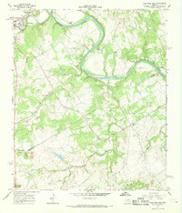
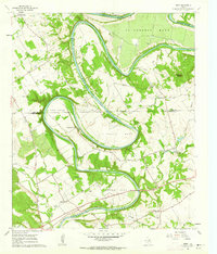 1961 Nemo1963 Print · USGSThe Brazos River winds through the Hood and Somervell County border in the early sixties, creating a landscape of deep river bends and small rural communities. Genealogists can trace family roots at Mitchell Bend Cem or Oldham Cem, and locate landmarks like Fort Spunkey and Mambrino.3 unique versions available
 - 1961 Map of Paluxy, 1963 Print
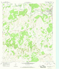
 1961 Paluxy1963 Print · USGSIn the early 1960s, the rural borderlands of Hood and Somervell Counties were defined by the winding Paluxy River and a network of family-named creeks. Genealogists can trace early homesteads and community hubs like Elm Grove Ch, Glenn Cem, and the settlement of Paluxy.2 unique versions available
 - 1961 Map of Bono, 1963 Print
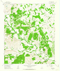
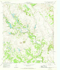
 1961 Bono1963 Print · USGSJohnson County and the surrounding ranch lands are captured here in the early sixties as the Brazos River winds through its massive oxbow. Researchers can locate the small settlement of Bono, the quiet Nemo Cem, and the early layout of Cleburne State Park.3 unique versions available
 - 1966 Map of Chalk Mountain, 1968 Print
 1966 Chalk Mountain1968 Print · USGSThe borderlands of Erath and Somervell counties come into focus during the mid-sixties, revealing a rural landscape of winding creeks and limestone hills. Genealogists can trace family landmarks and community centers like Chalk Mountain Ch, Plainview Ch, and Lesley Lake.2 unique versions available
 - 1966 Map of Camp Branch, 1968 Print
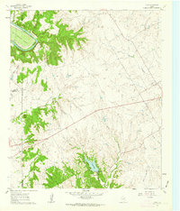
 1966 Camp Branch1968 Print · USGSThe Texas ranchlands at the Erath and Bosque county line are captured here in the mid-sixties, showing a landscape defined by cattle country and river forks. Genealogists and land researchers can locate the Flanary Cem, Surprise Valley Ranch, and the winding course of Duffau Creek.
 - 1966 Map of Glen Rose West, 1968 Print
 1966 Glen Rose West1968 Print · USGSGlen Rose and the surrounding river breaks are captured in the mid-1960s, showing a landscape defined by the winding Paluxy River and scattered rural communities. Genealogists can locate family landmarks like Lanham Mill Cem, Nancy Smith Cem, and the small settlement of Glass.2 unique versions available
 - 1966 Map of Walnut Springs West, 1968 Print
 1966 Walnut Springs West1968 Print · USGSNorthwest Bosque County in the mid-1960s shows a landscape of established cattle ranching and shifting transportation lines. You can trace the footprint of the Flat Top Ranch, locate the Fulton Cem, and see the abandoned rail line at Walnut Springs.
 - 1967 Map of Glen Rose East, 1968 Print
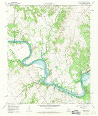
 1967 Glen Rose East1968 Print · USGSThe Brazos and Paluxy rivers meet in the Texas Hill Country during the late sixties, defining a landscape of riverside camps and rural outposts. Genealogists can trace the footprint of Glen Rose, locate White Ch, or explore the settlement at Eulogy.2 unique versions available
 - 1968 Map of Brazos Point, 1971 Print
 1968 Brazos Point1971 Print · USGSThe Brazos River and Lake Whitney define this borderland of Johnson, Bosque, and Somervell counties in the late sixties. Trace family sites at Stanford Cem or Baker Lain Cem, and locate old river landmarks like Brazos Point and Kimball Bend.2 unique versions available
End of results
Showing maps 1-10 of 10
Top cities of Somervell County
Frequently asked questions
- What are the different types of historical maps available for Somervell County?
- What is the oldest map of Somervell County?
- Where can I purchase historical maps of Somervell County for my home or office?
- Where can I download high-res historical maps of Somervell County?
- Are there historical topographic maps available for Somervell County?
- Is there historical aerial imagery available for Somervell County?
- Where are historical maps of Somervell County sourced from?