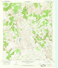
1966 Map of Chalk Mountain
USGS Topo · Published 1968About this map
Chalk Mountain rises as a prominent landmark along the jagged border of Erath and Somervell counties during the mid-1960s. The landscape is defined by its drainage systems, with Sycamore Creek and Pony Creek cutting through the northern reaches while the East Bosque River winds across the southern section. Settlement patterns are sparse and rural, focused around community cornerstones like the Chalk Mountain Ch, Cottonwood Ch, and Plainview Ch.
Find a feature on this map
25 named features on this map. Tap any name to fly to it.
Don’t see what you’re looking for? This feature index may not catch every label — zoom into the map to look around manually.
Map Details
Editions of this 1966 Chalk Mountain Map
2 editions found
Other maps of this area

1889 · Granbury
USGS Topo · 1:125,000

1890 · Stephenville
USGS Topo · 1:125,000

1920 · Stephenville
USGS Topo · 1:125,000

1931 · Tolar
USGS Topo · 1:62,500

1954 · Dallas
USGS Topo · 1:250,000

1954 · Abilene
USGS Topo · 1:250,000

1958 · Dallas
USGS Topo · 1:250,000

1958 · Abilene
USGS Topo · 1:250,000

1961 · Johnsville
USGS Topo · 1:24,000
1961 · Hill City
USGS Topo · 1:24,000