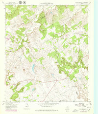
1966 Map of Chalk Mountain
USGS Topo · Published 1979About this map
The community of Chalk Mountain sits atop the high ground of the Texas Cross Timbers region, marking the boundary where Erath and Somervell counties meet. This 1960s-era topography, updated in the late 1970s, reveals a landscape defined by dramatic relief and drainage, with deep incisions like Long Hollow and Big Kid Hollow channeling water toward the East Bosque River and White Bluff Creek. The map documents the rural infrastructure of the period, from the Radio Tower and Roadside Park to the numerous scattered Gravel Pits and a Quarry that speak to the local geology and industry. Smaller family or community landmarks, including Chalk Mountain Ch, Plainview Ch, and several isolated Wells, indicate the persistent patterns of settlement across this broken terrain. Notable water features like Lesley Lake and Chimney Lake contrast with the rugged limestone hills, providing essential water sources in a region characterized by its namesake white outcroppings.
Find a feature on this map
29 named features on this map. Tap any name to fly to it.
Don’t see what you’re looking for? This feature index may not catch every label — zoom into the map to look around manually.
Map Details
Editions of this 1966 Chalk Mountain Map
2 editions found
Other maps of this area

1889 · Granbury
USGS Topo · 1:125,000

1890 · Stephenville
USGS Topo · 1:125,000

1920 · Stephenville
USGS Topo · 1:125,000

1931 · Tolar
USGS Topo · 1:62,500

1954 · Dallas
USGS Topo · 1:250,000

1954 · Abilene
USGS Topo · 1:250,000

1958 · Dallas
USGS Topo · 1:250,000

1958 · Abilene
USGS Topo · 1:250,000

1961 · Johnsville
USGS Topo · 1:24,000
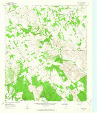
1961 · Hill City
USGS Topo · 1:24,000