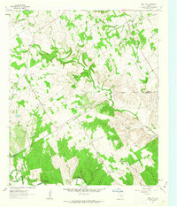
1961 Map of Hill City
USGS Topo · Published 1963About this map
Hill City and Neri anchor this early 1960s study of the rural landscape where the Hood and Somervell county line intersects. The terrain is defined by an intricate network of waterways, including the southern sweep of the Paluxy River and the northern reaches of Squaw Creek. This era of the landscape is marked by small-scale community foundations, evidenced by local landmarks like Neri Sch and the Prairie Creek Ch, as well as the Cedar Brake Girl Scout Camp near the riverbanks.
Find a feature on this map
24 named features on this map. Tap any name to fly to it.
Don’t see what you’re looking for? This feature index may not catch every label — zoom into the map to look around manually.
Map Details
Editions of this 1961 Hill City Map
Other maps of this area

1889 · Granbury
USGS Topo · 1:125,000

1923 · Granbury 2-a
USGS Topo · 1:48,000

1923 · Granbury 1-b
USGS Topo · 1:48,000

1924 · Granbury 1-c
USGS Topo · 1:48,000

1928 · Godley
USGS Topo · 1:62,500

1931 · Morgan
USGS Topo · 1:62,500

1931 · Tolar
USGS Topo · 1:62,500

1954 · Dallas
USGS Topo · 1:250,000

1958 · Dallas
USGS Topo · 1:250,000
1960 · Tolar
USGS Topo · 1:24,000