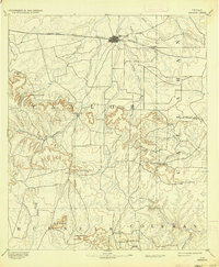
1958 Map of Abilene
USGS Topo · Published 1958About this map
Abilene serves as the focal point of this mid-century West Texas landscape, where the growing aviation presence at Abilene AFB meets a deep frontier history marked by the Fort Griffin Ruins and Fort Phantom Hill Ruins. The map illustrates a region in transition, balancing established cattle and agricultural hubs like Stamford and Anson with a pervasive energy economy evidenced by numerous Oil Fields and an extensive network of Underground pipelines. Transportation is dominated by the Texas & Pacific RR and Santa Fe RR, which dictate the alignment of towns such as Cisco, Eastland, and Ranger. To the east, the terrain becomes more varied as the Brazos River feeds into Possum Kingdom Lake, surrounded by landmarks like Kyle Mountain and Wolf Mountain. Smaller, storied communities including Desdemona and Rising Star appear alongside family-named peaks, providing a clear picture of rural Texas life before the later expansion of the interstate system.
Find a feature on this map
215 named features on this map. Tap any name to fly to it.
Don’t see what you’re looking for? This feature index may not catch every label — zoom into the map to look around manually.
Map Details
Editions of this 1958 Abilene Map
This is the sole edition of this map. No revisions or reprints were ever made.
Historical Maps of Abilene Through Time
5 maps found