Old Maps of Terrell County, Texas for Academic Research
Study the evolution of Terrell County with 322 high-resolution historic maps. Whether you're teaching, researching, or modeling changes in land use, these maps provide essential visual documentation of urban, environmental, and geographic change.
- Analyze long-term change: Track patterns in development, transportation, and natural features.
- Ideal for environmental or urban studies: Support academic projects with primary historical map data.
- Use in the classroom or lab: Educators and researchers rely on these maps to bring historical context to life.
These maps are a powerful tool for teaching, research, and visualizing how Terrell County has changed over the decades.
Terrell County, TX maps
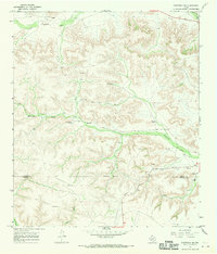
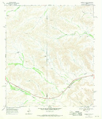
(322)- 1918 Map of Dryden Crossing
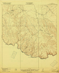 1918 Dryden Crossing1918 Print · USGSTerrell County and the Mexico border appear in the late Great War era as a landscape of isolated ranching and essential river fords. Trace historic crossings at Dryden Crossing and Shafter Crossing, or locate early homesteads like Taylor Ranch and Loma Vista.3 unique versions available
 - 1918 Map of Indian Wells
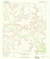
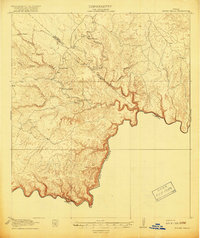 1918 Indian Wells1918 Print · USGSThe West Texas borderlands appear in their early ranching prime just before the 1920s, showing the isolated outposts along the river. Genealogists and local historians can trace legacy holdings at Garcia Ranch, Stewart Ranch, and the settlement of San Francisco.4 unique versions available
 - 1920 Map of Longfellow
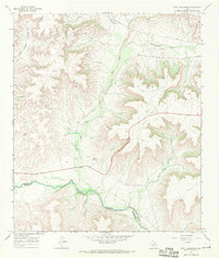
 1920 Longfellow1920 Print · USGSRailroad outposts and high desert terrain define this West Texas survey from the early twentieth century. Genealogists and historians can trace the Southern Pacific line through stops like Purrington, Tesnus, and Rosenfeld, along with landmarks like the Pittsburg Boring.
 - 1928 Map of Sanderson
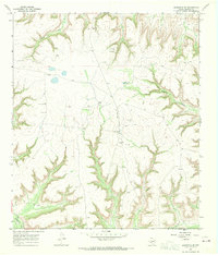
 1928 Sanderson1928 Print · USGSTerrell County ranching and railroad life come into focus in the late 1920s, showing the area's transition from frontier outposts to a connected rail corridor. Genealogists and historians can locate remote family sites like Big Canyon Headquarters or trace the old Southern Pacific line through Sanderson and Thurston.
 - 1929 Map of Sheffield
 1929 Sheffield1929 Print · USGSWest Texas ranching and the early oil boom meet along the Pecos River in the late twenties. Researchers can trace the Old Spanish Trail through Sheffield or locate historical sites like Fort Lancaster and the Yates Oil Field.
 - 1929 Map of Independence Draw Quadrangle
 1929 Independence Draw Quadrangle1929 Print · USGSPecos and Terrell Counties come into focus during the late 1920s as ranching outposts and the Old Spanish Trail defined the West Texas landscape. Genealogists and historians can trace family-named sites like Harral Headquarters, the Salt Works, and the abandoned site at Free (Abd).
 - 1943 Map of Malvado, 1957 Print
 1943 Malvado1957 Print · USGSIn the early 1940s, the remote borderlands of West Texas were defined by the Southern Pacific railroad and isolated ranching outposts. Genealogists and historians can trace family landholdings like Whitehead Ranch, the settlement of Malvado, and the winding path of Lozier Canyon.
 - 1944 Map of Malvado
 1944 Malvado1944 Print · USGSWestern Terrell County in the 1940s is a rugged landscape of deep canyons and isolated ranching outposts along the Mexican border. Genealogists and local historians can trace legacy family holdings like Williams Ranch and Foster Ranch near the winding Rio Grande.
 - 1954 Map of Fort Stockton, 1965 Print
 1954 Fort Stockton1965 Print · USGSWest Texas ranching and the early energy industry converge in this mid-century survey of the Trans-Pecos. Genealogists and historians can locate specific family lands like Graef Brothers Ranch and trace the paths of the Old Spanish Trail and the Southern Pacific railroad.3 unique versions available
 - 1954 Map of Sonora, 1965 Print
 1954 Sonora1965 Print · USGSThe Edwards Plateau and West Texas ranching country come alive in this mid-century survey of the canyons and plateaus. Genealogists and historians can trace the remote settlements of Pandale and Loma Alta or follow the path of the Panhandle and Santa Fe RR.2 unique versions available
 - 1958 Map of Sonora
 1958 Sonora1958 Print · USGSThe Edwards Plateau and Trans-Pecos region come alive in the late fifties, showing a landscape of remote ranchlands and historic frontier outposts. Trace the legacy of Fort Lancaster Ruins, the limestone depths of Devils Sinkhole Cavern, and the path of the Pecos River.
 - 1958 Map of Fort Stockton
 1958 Fort Stockton1958 Print · USGSThe Trans-Pecos region of West Texas in the late fifties is a landscape of vast mesas and isolated ranching hubs. Genealogists and historians can trace the paths of the Texas and New Orleans RR through Alpine or locate early settlements like Bakersfield and Sanderson.
 - 1958 Map of Del Rio, 1970 Print
 1958 Del Rio1970 Print · USGSThe Texas-Mexico borderlands come alive in the late fifties, showing the confluence of the Rio Grande and the emerging Amistad Reservoir. Trace the lineage of the Southern Pacific rail line through stops at Pumpville, Shumla, and the mining vicinity of Blewett.2 unique versions available
 - 1959 Map of Emory Peak, 1967 Print
 1959 Emory Peak1967 Print · USGSThe Big Bend country of West Texas is documented here just as the national park was becoming a major destination. Researchers can trace remote desert outposts like Lajitas, Castolon, and the Terlingua Post Office along the winding Rio Grande.3 unique versions available
 - 1964 Map of Del Rio
 1964 Del Rio1964 Print · USGSAlong the Mexican border during the mid-sixties, this area centered on the confluence of the Rio Grande and Devils River. Researchers can trace the Southern Pacific line through isolated stops like Pumpville or locate military and industrial sites such as Laughlin Air Force Base and the mines at Blewett.
 - 1965 Map of Emory Peak
 1965 Emory Peak1965 Print · USGSThe Big Bend backcountry in the mid-1960s reveals a desert landscape of remote ranches and mercury mining. Trace the historic boundary along the Rio Grande and locate landmarks like the Fresno Mine and Panther Spring.
 - 1967 Map of Sheffield NW, 1970 Print
 1967 Sheffield NW1970 Print · USGSThe Pecos and Terrell county border country comes to life in this late 1960s study of the West Texas landscape. Genealogists and historians can trace the established Cannon Ranch, Slaughter Ranch, and the Perkins Windmill across the draws.2 unique versions available
 - 1967 Map of Horsehead Canyon, 1970 Print
 1967 Horsehead Canyon1970 Print · USGSTerrell County during the late 1960s is defined by a deep-cut canyon system and the growing reach of energy infrastructure. Researchers can trace the path of Independence Creek and identify industrial landmarks like the Pumping Sta and scattered Gas Wells.
 - 1967 Map of Fort Lancaster, 1970 Print
 1967 Fort Lancaster1970 Print · USGSThe West Texas frontier meets the mid-century oil industry in this late 1960s survey of the Pecos River valley. Historians and researchers can locate the site of Fort Lancaster (Ruins) and trace the industrial footprint of Oil Wells across COX HILL.
 - 1967 Map of Sheffield SE, 1970 Print
 1967 Sheffield SE1970 Print · USGSThe rugged Trans-Pecos terrain of Terrell County is captured here in the late sixties, showing a landscape defined by deep draws and remote ranching outposts. Researchers can trace the livestock operations of the Allison Ranch and locate specific water landmarks like East Martin Windmill and Independence Creek.
 - 1967 Map of Dead Man Canyon, 1970 Print
 1967 Dead Man Canyon1970 Print · USGSThe West Texas frontier along the Pecos River is captured here in the late sixties, a time of isolated ranching and early petroleum exploration. Genealogists and historians can locate the Dead Man Windmill Grave and trace early crossings like the Ford near Reagan Canyon.
 - 1967 Map of Sheffield, 1970 Print
 1967 Sheffield1970 Print · USGSSheffield and the Pecos River valley are captured in the late sixties, showing a landscape defined by ranching and oil. Researchers can trace family sites at Sheffield Cem and locate remote landmarks like Greer Airfield or Squaw Peak.
 - 1968 Map of Big Brindle Canyon, 1971 Print
 1968 Big Brindle Canyon1971 Print · USGSWest Texas ranching life in the late sixties centers on isolated homesteads and vital water sources among the deep draws of the Trans-Pecos. Researchers can trace the boundaries of the Brown Ranch, Murrah Ranch, and the southern Ranchito near Maxon Creek.
 - 1968 Map of Toms Canyon, 1971 Print
 1968 Toms Canyon1971 Print · USGSThe arid ranchlands of the Trans-Pecos come into focus in the late 1960s, showing the vital water systems of the Wildcat Mountains. Researchers can locate historic family holdings and landmarks like Downie Ranch, Standifer Gap, and Cliett Windmills.2 unique versions available
 - 1968 Map of Ninemile Ranch, 1971 Print
 1968 Ninemile Ranch1971 Print · USGSRanching life and rail transport define this Terrell County landscape in the late sixties. Researchers can trace the Southern Pacific line through Sanderson Canyon and locate remote landmarks like Ninemile Ranch, Emerson, and Jackson Tank.2 unique versions available
Showing maps 1-25 of 322
Top cities of Terrell County
Frequently asked questions
- What are the different types of historical maps available for Terrell County?
- What is the oldest map of Terrell County?
- Where can I purchase historical maps of Terrell County for my home or office?
- Where can I download high-res historical maps of Terrell County?
- Are there historical topographic maps available for Terrell County?
- Is there historical aerial imagery available for Terrell County?
- Where are historical maps of Terrell County sourced from?