1980s Maps of Manor, Texas
Explore 5 historic maps of Manor from the 1980s. These maps offer a rare glimpse into what life looked like during the 1980s — showing old roads, neighborhoods, homes, and landmarks that have changed or disappeared over time.
Whether you're researching your family's past, planning a metal detecting trip, or studying how Manor's landscape evolved across the 1980s, these high-resolution maps are a powerful tool for exploring the history of this region.
- Focus on a specific era: All maps on this page are from the 1980s, giving you a focused view of this time period.
- See what’s changed: Compare century-old streets, trails, and buildings to today's modern landscape using overlays and satellite layers.
- Research with precision: Use these maps for genealogy, historical research, land use analysis, or educational projects.
- View, download, or print: Maps are fully viewable online in high resolution, and can be downloaded or printed for your own records.
Start exploring Manor's history through authentic maps from the 1980s. This is your window into the past.
Manor, TX maps
(5)- 1982 Map of Coupland
 1982 Coupland1982 Print · USGSSettlements along the Williamson and Travis county line are captured here in the early eighties, centered on the railroad hub of Coupland. Researchers can trace rural heritage at sites like New Sweden Ch and family burial grounds including Bethlehem Cem.2 unique versions available
 - 1982 Map of Elgin West
 1982 Elgin West1982 Print · USGSNear the Travis and Bastrop county line in the early eighties, this area shows a landscape of winding creeks and rural rail stops. Genealogists can trace family footprints at Hog Eye Cem and Speir Cem or along the Southern Pacific tracks near Littig.
 - 1985 Map of Austin
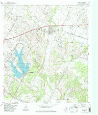
 1985 Austin1985 Print · USGSCentral Texas in the mid-eighties reveals a region in transition, balancing rapid urban growth in Austin with deep-rooted rural landscapes. Genealogists and historians can trace family locations near St Johns Ch, the Science Hall schoolhouse, and long-standing communities like Webberville and Manchaca.3 unique versions available
 - 1987 Map of Pflugerville East, 1988 Print
 1987 Pflugerville East1988 Print · USGSThe rural stretches between Pflugerville and New Sweden are shown here just as the Austin suburbs began to expand in the late eighties. Researchers can locate family landmarks like Pfluger Cem, trace the Missouri Pacific line, and find small communities like Cele.
 - 1988 Map of Manor
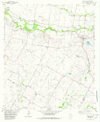
 1988 Manor1988 Print · USGSNortheastern Travis County appears in the late eighties as Austin's city limits began to reach toward the farming community of Manor. Researchers can locate several historical burial sites including Rosehill Cem and Glasscock Cem, alongside the waters of Walter E Long Lake.
End of results
Showing maps 1-5 of 5
Top cities near Manor
- Austin historical maps
- Round Rock historical maps
- Georgetown historical maps
- Pflugerville historical maps
- Hutto historical maps
- Taylor historical maps
See more
Top neighborhoods of Manor
- Stonewater historical maps
- Hamilton Point historical maps
- Presidential Glen historical maps
- Wildhorse Creek historical maps
Frequently asked questions
- What are the different types of historical maps available for Manor?
- What is the oldest map of Manor?
- Where can I purchase historical maps of Manor for my home or office?
- Where can I download high-res historical maps of Manor?
- Are there historical topographic maps available for Manor?
- Is there historical aerial imagery available for Manor?
- Where are historical maps of Manor sourced from?