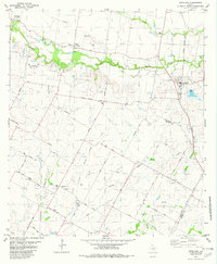
1982 Map of Coupland
USGS Topo · Published 1982About this map
Brushy Creek carves a winding path through this central Texas landscape, marking the boundary between Williamson and Travis counties during the early 1980s. The settlement of Coupland serves as a primary hub, situated along the Missouri Kansas Texas railroad line. The surrounding rural area is characterized by a dense network of family-named roads and historic community centers, reflecting a long-standing agricultural heritage.
Find a feature on this map
45 named features on this map. Tap any name to fly to it.
Don’t see what you’re looking for? This feature index may not catch every label — zoom into the map to look around manually.
Map Details
Editions of this 1982 Coupland Map
2 editions found
Other maps of this area

1885 · Taylor
USGS Topo · 1:125,000

1885 · Bastrop
USGS Topo · 1:125,000

1887 · Taylor
USGS Topo · 1:125,000

1893 · Georgetown
USGS Topo · 1:125,000

1893 · Bastrop
USGS Topo · 1:125,000

1894 · Taylor
USGS Topo · 1:125,000

1896 · Austin
USGS Topo · 1:125,000

1897 · Austin
USGS Topo · 1:125,000

1904 · Bastrop
USGS Topo · 1:125,000

1910 · Austin
USGS Topo · 1:125,000