1960s Maps of Trinity, Texas
Explore 2 historic maps of Trinity from the 1960s. These maps offer a rare glimpse into what life looked like during the 1960s — showing old roads, neighborhoods, homes, and landmarks that have changed or disappeared over time.
Whether you're researching your family's past, planning a metal detecting trip, or studying how Trinity's landscape evolved across the 1960s, these high-resolution maps are a powerful tool for exploring the history of this region.
- Focus on a specific era: All maps on this page are from the 1960s, giving you a focused view of this time period.
- See what’s changed: Compare century-old streets, trails, and buildings to today's modern landscape using overlays and satellite layers.
- Research with precision: Use these maps for genealogy, historical research, land use analysis, or educational projects.
- View, download, or print: Maps are fully viewable online in high resolution, and can be downloaded or printed for your own records.
Start exploring Trinity's history through authentic maps from the 1960s. This is your window into the past.
Trinity, TX maps
(2)- 1960 Map of Trinity West, 1962 Print
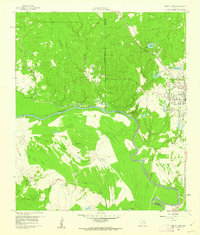 1960 Trinity West1962 Print · USGSThe Trinity River bottomlands south of the town of Trinity come into focus in the early 1960s as a landscape of railroads and institutional farms. Researchers can trace the path of the Waco Beaumont Trinity and Sabine rail line or locate the grounds of the Smither Prison Farm and Mt Olive Ch.3 unique versions available
 - 1960 Map of Trinity East, 1962 Print
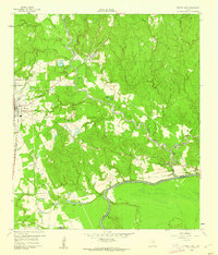 1960 Trinity East1962 Print · USGSThe community of Trinity and its riverfront surroundings are captured in the early 1960s, showing the intersection of rail and river life. Researchers can trace the Missouri Pacific line or follow the Old Railroad Grade past Skaines Lake and the settlement of Sebastopol.3 unique versions available
End of results
Showing maps 1-2 of 2
Top cities near Trinity
- Huntsville historical maps
- Onalaska historical maps
- Groveton historical maps
- Lovelady historical maps
- Riverside historical maps
Top neighborhoods of Trinity
Frequently asked questions
- What are the different types of historical maps available for Trinity?
- What is the oldest map of Trinity?
- Where can I purchase historical maps of Trinity for my home or office?
- Where can I download high-res historical maps of Trinity?
- Are there historical topographic maps available for Trinity?
- Is there historical aerial imagery available for Trinity?
- Where are historical maps of Trinity sourced from?