
1960 Map of Trinity East
USGS Topo · Published 1962About this map
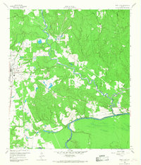
The town of Trinity serves as the focal point for this 1960s survey, positioned at the edge of a landscape defined by the winding course of White Rock Creek and the Trinity River. The region’s economic and transport history is clearly etched into the terrain, where the operational Missouri Pacific line contrasts with an extensive Old Railroad Grade that meanders through the creek bottoms towards the community of Sebastopol. The map reveals a transition between concentrated settlement at Mill Town and the more industrial features like a Gravel Pit and several utility pipelines.
Find a feature on this map
16 named features on this map. Tap any name to fly to it.
Don’t see what you’re looking for? This feature index may not catch every label — zoom into the map to look around manually.
Map Details
Editions of this 1960 Trinity East Map
Other maps of this area

1953 · Palestine
USGS Topo · 1:250,000

1954 · Beaumont
USGS Topo · 1:250,000

1957 · Beaumont
USGS Topo · 1:250,000

1957 · Palestine
USGS Topo · 1:250,000

1960 · Trinity West
USGS Topo · 1:24,000

1960 · Carlisle
USGS Topo · 1:24,000

1961 · Staley
USGS Topo · 1:24,000

1961 · Riverside
USGS Topo · 1:24,000

1962 · Lovelady South
USGS Topo · 1:24,000

1962 · Glendale
USGS Topo · 1:24,000