
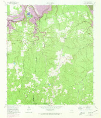
1961 Map of Staley
USGS Topo · Published 1962About this map
Trinity River winds along the northern boundary of this landscape, carving through the Sulphur Bluffs and feeding a network of oxbow lakes including Belle and Ford Lake, Black Lake, and Thomas Lake. Much of the territory is defined by the dense woodlands of the Sam Houston National Forest, where the small settlement of Staley (Embryfield) serves as a primary point of reference. The terrain is deeply dissected by a series of south-flowing waterways, most notably Carolina Creek and its many branches.
Find a feature on this map
34 named features on this map. Tap any name to fly to it.
Don’t see what you’re looking for? This feature index may not catch every label — zoom into the map to look around manually.
Map Details
Editions of this 1961 Staley Map
2 editions found
Other maps of this area

1954 · Beaumont
USGS Topo · 1:250,000

1957 · Beaumont
USGS Topo · 1:250,000

1960 · Trinity West
USGS Topo · 1:24,000

1960 · Trinity East
USGS Topo · 1:24,000

1960 · Carlisle
USGS Topo · 1:24,000

1960 · Stephen Creek
USGS Topo · 1:24,000

1960 · Phelps
USGS Topo · 1:24,000

1961 · Riverside
USGS Topo · 1:24,000

1961 · Oakhurst
USGS Topo · 1:24,000

1984 · Beaumont
USGS Topo · 1:250,000