1960s Maps of Val Verde County, Texas
Explore 4 historic maps of Val Verde County from the 1960s. These maps offer a rare glimpse into what life looked like during the 1960s — showing old roads, neighborhoods, homes, and landmarks that have changed or disappeared over time.
Whether you're researching your family's past, planning a metal detecting trip, or studying how Val Verde County's landscape evolved across the 1960s, these high-resolution maps are a powerful tool for exploring the history of this region.
- Focus on a specific era: All maps on this page are from the 1960s, giving you a focused view of this time period.
- See what’s changed: Compare century-old streets, trails, and buildings to today's modern landscape using overlays and satellite layers.
- Research with precision: Use these maps for genealogy, historical research, land use analysis, or educational projects.
- View, download, or print: Maps are fully viewable online in high resolution, and can be downloaded or printed for your own records.
Start exploring Val Verde County's history through authentic maps from the 1960s. This is your window into the past.
Val Verde County, TX maps
(4)- 1964 Map of Del Rio
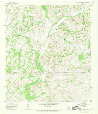
 1964 Del Rio1964 Print · USGSAlong the Mexican border during the mid-sixties, this area centered on the confluence of the Rio Grande and Devils River. Researchers can trace the Southern Pacific line through isolated stops like Pumpville or locate military and industrial sites such as Laughlin Air Force Base and the mines at Blewett.
 - 1967 Map of Dunbar Draw SW, 1969 Print
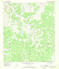 1967 Dunbar Draw SW1969 Print · USGSSutton and Edwards Counties are shown here in the late sixties as a landscape of working ranches and oil production. Genealogists and researchers can locate family properties like Rex Cusenbary Ranch and the Texas A and M Experimental Station.3 unique versions available
 - 1967 Map of Flat Rock Draw SE, 1969 Print
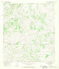 1967 Flat Rock Draw SE1969 Print · USGSSutton and Val Verde Counties in the late sixties were defined by expansive ranching operations and the infrastructure of the developing oil and gas industry. Researchers can trace historic family holdings like the Martin Ranch and Keene Ranch alongside early Gravel Pits and a regional Pipeline.2 unique versions available
 - 1967 Map of Flat Rock Draw SW, 1970 Print
 1967 Flat Rock Draw SW1970 Print · USGSThe Texas Hill Country at the meeting of Crockett and Sutton counties shows a landscape of isolated ranching life in the late 1960s. Genealogists and historians can trace the large holdings of the Phillips Ranch and Hunnicutt Ranch or locate geographic landmarks like Pot Hole City Canyon.2 unique versions available
End of results
Showing maps 1-4 of 4
Top cities of Val Verde County
- Del Rio historical maps
- Val Verde Park historical maps
- Comstock historical maps
- Lake View historical maps
Frequently asked questions
- What are the different types of historical maps available for Val Verde County?
- What is the oldest map of Val Verde County?
- Where can I purchase historical maps of Val Verde County for my home or office?
- Where can I download high-res historical maps of Val Verde County?
- Are there historical topographic maps available for Val Verde County?
- Is there historical aerial imagery available for Val Verde County?
- Where are historical maps of Val Verde County sourced from?