1980s Maps of Val Verde County, Texas
Explore 12 historic maps of Val Verde County from the 1980s. These maps offer a rare glimpse into what life looked like during the 1980s — showing old roads, neighborhoods, homes, and landmarks that have changed or disappeared over time.
Whether you're researching your family's past, planning a metal detecting trip, or studying how Val Verde County's landscape evolved across the 1980s, these high-resolution maps are a powerful tool for exploring the history of this region.
- Focus on a specific era: All maps on this page are from the 1980s, giving you a focused view of this time period.
- See what’s changed: Compare century-old streets, trails, and buildings to today's modern landscape using overlays and satellite layers.
- Research with precision: Use these maps for genealogy, historical research, land use analysis, or educational projects.
- View, download, or print: Maps are fully viewable online in high resolution, and can be downloaded or printed for your own records.
Start exploring Val Verde County's history through authentic maps from the 1980s. This is your window into the past.
Val Verde County, TX maps
(12)- 1980 Map of Geddis Canyon East
 1980 Geddis Canyon East1980 Print · USGSThe Trans-Pecos region during the late 1970s reveals a landscape of energy production and remote ranching outposts. Researchers can trace the railway activity at Terrell Station and locate natural water sources like Johnson Seep and Packingham Spring.
 - 1980 Map of Roundhill Ranch
 1980 Roundhill Ranch1980 Print · USGSVal Verde County ranching country is captured here during the late 1970s, showing the isolated outposts of the Texas high desert. Researchers can locate specific water sources and landmarks like Roundhill Ranch, Bassett, and the prominent Osman Draw.
 - 1980 Map of Meyers Canyon NE
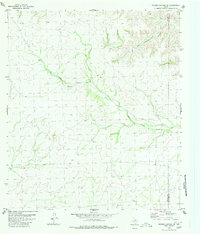 1980 Meyers Canyon NE1980 Print · USGSThe remote West Texas borderlands between Terrell Co and Val Verde Co are captured here in the early eighties. Local researchers and surveyors can trace the deep seasonal drainages of Big Hackberry Canyon and Big Fielder Draw.
 - 1980 Map of Sevenmile Canyon
 1980 Sevenmile Canyon1980 Print · USGSThe Terrell and Val Verde county line runs through this high-desert landscape in the late 1970s. Researchers can trace remote ranching infrastructure and desert drainages like Sevenmile Canyon, Osman Draw, and Hoddy.
 - 1980 Map of Ramsey Canyon
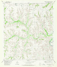
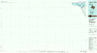
 1980 Ramsey Canyon1980 Print · USGSThe Val Verde County borderlands are captured here in the early eighties, where the Rio Grande meets the expanding Amistad Reservoir. Researchers can trace the Old Railroad Grade and locate remote landmarks like Foster Spring and Hodge.2 unique versions available
 - 1980 Map of Pumpville
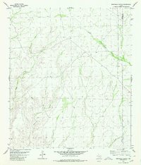
 1980 Pumpville1980 Print · USGSVal Verde County's high-desert rail corridor is captured here in the late twentieth century as the tracks navigate the deep draws of West Texas. Researchers can trace the original path of the Old Railroad Grade and the settlement of Pumpville along the Southern Pacific line.
 - 1985 Map of Amistad Village
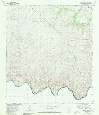
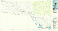
 1985 Amistad Village1985 Print · USGSThe Texas-Mexico borderlands in the mid-eighties show a landscape defined by massive water management and international transit. Trace the impact of the Amistad Reservoir on the local terrain, locating the Amistad Dam, the Southern Pacific line, and Amistad Village.2 unique versions available
 - 1985 Map of Comstock, 1986 Print
 1985 Comstock1986 Print · USGSVal Verde County was a landscape of deep canyons and borderland outposts in the mid-1980s. Local researchers can trace the Southern Pacific rail line through Langtry and Pumpville or locate landmarks like Big Tree Cave.2 unique versions available
 - 1985 Map of Rocksprings, 1986 Print
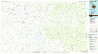
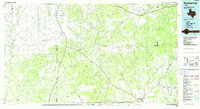 1985 Rocksprings1986 Print · USGSThe Edwards Plateau in the mid-1980s is captured here at the junction of four counties, centered on the settlement of Rocksprings. Geologists and local historians can trace the network of drainage draws and subterranean features like Felton Cave, Word Cave, and the path of the Devils River.
 - 1985 Map of Camp Wood, 1986 Print
 1985 Camp Wood1986 Print · USGSThe Edwards Plateau and Nueces River Valley are captured here in the mid-eighties, showing a landscape of isolated ranching hubs and rugged drainage basins. Researchers can trace the Old Railroad Grade or locate historic springs like Dripping Springs and Red Camp Spring.2 unique versions available
 - 1985 Map of Devils Draw, 1986 Print
 1985 Devils Draw1986 Print · USGSThe Pecos and Devils River country of Southwest Texas is captured in the mid-eighties before modern developments. Researchers can trace the Southern Pacific RR through Terrell Station or locate remote outposts like Pandale and Juno.2 unique versions available
 - 1986 Map of Del Rio
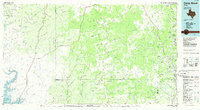
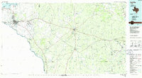 1986 Del Rio1986 Print · USGSThe West Texas borderlands come alive in the mid-eighties as Del Rio expands and Laughlin AFB anchors the local economy. Researchers can trace the rail corridors through Spofford and Cline or locate family sites near Alamo Village.2 unique versions available
End of results
Showing maps 1-12 of 12
Top cities of Val Verde County
- Del Rio historical maps
- Val Verde Park historical maps
- Comstock historical maps
- Lake View historical maps
Frequently asked questions
- What are the different types of historical maps available for Val Verde County?
- What is the oldest map of Val Verde County?
- Where can I purchase historical maps of Val Verde County for my home or office?
- Where can I download high-res historical maps of Val Verde County?
- Are there historical topographic maps available for Val Verde County?
- Is there historical aerial imagery available for Val Verde County?
- Where are historical maps of Val Verde County sourced from?