Old Maps of Hackberry Crossing, Texas for Academic Research
Study the evolution of Hackberry Crossing with 9 high-resolution historic maps. Whether you're teaching, researching, or modeling changes in land use, these maps provide essential visual documentation of urban, environmental, and geographic change.
- Analyze long-term change: Track patterns in development, transportation, and natural features.
- Ideal for environmental or urban studies: Support academic projects with primary historical map data.
- Use in the classroom or lab: Educators and researchers rely on these maps to bring historical context to life.
These maps are a powerful tool for teaching, research, and visualizing how Hackberry Crossing has changed over the decades.
Hackberry Crossing, TX maps
(9)- 1954 Map of Sonora, 1965 Print
 1954 Sonora1965 Print · USGSThe Edwards Plateau and West Texas ranching country come alive in this mid-century survey of the canyons and plateaus. Genealogists and historians can trace the remote settlements of Pandale and Loma Alta or follow the path of the Panhandle and Santa Fe RR.2 unique versions available
 - 1958 Map of Sonora
 1958 Sonora1958 Print · USGSThe Edwards Plateau and Trans-Pecos region come alive in the late fifties, showing a landscape of remote ranchlands and historic frontier outposts. Trace the legacy of Fort Lancaster Ruins, the limestone depths of Devils Sinkhole Cavern, and the path of the Pecos River.
 - 1973 Map of Hackberry Crossing, 1976 Print
 1973 Hackberry Crossing1976 Print · USGSVal Verde County at the start of the seventies is a landscape of remote river crossings and deep canyons. Researchers can trace the path of the Pecos River to the Ford Hackberry Crossing and locate isolated landmarks like Stapp Canyon.
 - 1985 Map of Devils Draw, 1986 Print
 1985 Devils Draw1986 Print · USGSThe Pecos and Devils River country of Southwest Texas is captured in the mid-eighties before modern developments. Researchers can trace the Southern Pacific RR through Terrell Station or locate remote outposts like Pandale and Juno.2 unique versions available
 - 2010 Map of Hackberry Crossing, 2010 Print
 2010 Hackberry Crossing2010 Print · USGSCovers Hackberry Crossing, including Val Verde County, United States, and other nearby areas
 - 2012 Map of Hackberry Crossing, 2012 Print
 2012 Hackberry Crossing2012 Print · USGSCovers Hackberry Crossing, including Val Verde County, United States, and other nearby areas
 - 2016 Map of Hackberry Crossing, 2016 Print
 2016 Hackberry Crossing2016 Print · USGSCovers Hackberry Crossing, including Val Verde County, United States, and other nearby areas
 - 2019 Map of Hackberry Crossing, 2019 Print
 2019 Hackberry Crossing2019 Print · USGSCovers Hackberry Crossing, including Val Verde County, United States, and other nearby areas
 - 2022 Map of Hackberry Crossing, 2022 Print
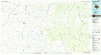
 2022 Hackberry Crossing2022 Print · USGSVal Verde County at the start of the 2020s remains a landscape of dramatic canyons and high plateaus. Researchers can trace the rugged drainage patterns of the Pecos River and find isolated landmarks like Big Hackberry Canyon and Pumpville Rd.
End of results
Showing maps 1-9 of 9
Frequently asked questions
- What are the different types of historical maps available for Hackberry Crossing?
- What is the oldest map of Hackberry Crossing?
- Where can I purchase historical maps of Hackberry Crossing for my home or office?
- Where can I download high-res historical maps of Hackberry Crossing?
- Are there historical topographic maps available for Hackberry Crossing?
- Is there historical aerial imagery available for Hackberry Crossing?
- Where are historical maps of Hackberry Crossing sourced from?