1960s Maps of Wills Point, Texas
Explore 2 historic maps of Wills Point from the 1960s. These maps offer a rare glimpse into what life looked like during the 1960s — showing old roads, neighborhoods, homes, and landmarks that have changed or disappeared over time.
Whether you're researching your family's past, planning a metal detecting trip, or studying how Wills Point's landscape evolved across the 1960s, these high-resolution maps are a powerful tool for exploring the history of this region.
- Focus on a specific era: All maps on this page are from the 1960s, giving you a focused view of this time period.
- See what’s changed: Compare century-old streets, trails, and buildings to today's modern landscape using overlays and satellite layers.
- Research with precision: Use these maps for genealogy, historical research, land use analysis, or educational projects.
- View, download, or print: Maps are fully viewable online in high resolution, and can be downloaded or printed for your own records.
Start exploring Wills Point's history through authentic maps from the 1960s. This is your window into the past.
Wills Point, TX maps
(2)- 1962 Map of Wills Point, 1965 Print
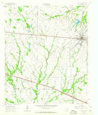 1962 Wills Point1965 Print · USGSWills Point and the surrounding Van Zandt County countryside are shown here in the early 1960s, centered on the Texas and Pacific rail line. Genealogists can trace family landmarks like Union Grove Cem, Allen Cem, and the small settlement of Hiram.2 unique versions available
 - 1962 Map of Edgewood, 1966 Print
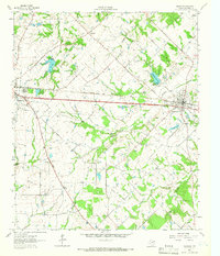 1962 Edgewood1966 Print · USGSThe rail-corridor towns of Van Zandt County appear here in the early sixties, caught between their agricultural roots and modern infrastructure. Genealogists can locate several rural landmarks and burial sites, including White Rose Cem, Rock Hill Cem, and Rainey's Chapel.2 unique versions available
End of results
Showing maps 1-2 of 2
Top cities near Wills Point
- Terrell historical maps
- Canton historical maps
- Canton historical maps
- West Tawakoni historical maps
- West Tawakoni historical maps
- Emory historical maps
See more
Frequently asked questions
- What are the different types of historical maps available for Wills Point?
- What is the oldest map of Wills Point?
- Where can I purchase historical maps of Wills Point for my home or office?
- Where can I download high-res historical maps of Wills Point?
- Are there historical topographic maps available for Wills Point?
- Is there historical aerial imagery available for Wills Point?
- Where are historical maps of Wills Point sourced from?