
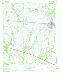
1962 Map of Wills Point
USGS Topo · Published 1965About this map
Wills Point serves as the primary hub in this early 1960s landscape, positioned along the vital corridor of the Texas and Pacific railroad. The town is flanked by municipal infrastructure like the Wills Point Reservoir and Filtration Plant to the north, reflecting mid-century water management expansion. Beyond the town limits, the terrain is defined by a dense network of drainage systems including Rocky Cedar Creek, Mc Bee Creek, and Wolf Creek, which likely dictated the placement of rural homesteads and agricultural plots.
Find a feature on this map
30 named features on this map. Tap any name to fly to it.
Don’t see what you’re looking for? This feature index may not catch every label — zoom into the map to look around manually.
Map Details
Editions of this 1962 Wills Point Map
2 editions found
Other maps of this area

1954 · Dallas
USGS Topo · 1:250,000

1956 · Tyler
USGS Topo · 1:250,000

1956 · Quinlan
USGS Topo · 1:62,500

1956 · Emory
USGS Topo · 1:62,500

1958 · Dallas
USGS Topo · 1:250,000

1962 · Myrtle Springs
USGS Topo · 1:24,000

1962 · Elmo
USGS Topo · 1:24,000

1962 · Cedarvale
USGS Topo · 1:24,000
1962 · Ola
USGS Topo · 1:24,000
1962 · Edgewood
USGS Topo · 1:24,000