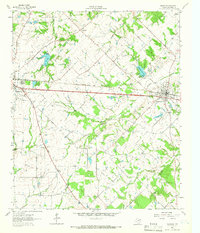
1962 Map of Edgewood
USGS Topo · Published 1966About this map
The Texas and Pacific railroad forms the central spine of this East Texas landscape, anchoring the parallel growth of Wills Point and Edgewood. In the early 1960s, these communities are defined by a mix of agricultural tradition and new infrastructure, seen in the numerous family and community burial grounds such as White Rose Cem and Ellis Chapel Cem. The terrain is drained by a dense network of tributaries like Giladon Creek and Crooked Creek, which feed into several local recreational and municipal reservoirs, including the Fin and Feathers Club Lake and Old City Lake. Small-scale industrial activity is evident through various Sandpits and localized resource extraction at Wills No 2. Deep-rooted rural social structures remain visible through country congregations like Rainey's Chapel and Highland Ch, which serve the outlying farmsteads scattered between the rail line and the wooded bottomlands.
Find a feature on this map
38 named features on this map. Tap any name to fly to it.
Don’t see what you’re looking for? This feature index may not catch every label — zoom into the map to look around manually.
Map Details
Editions of this 1962 Edgewood Map
2 editions found
Other maps of this area

1954 · Dallas
USGS Topo · 1:250,000

1956 · Tyler
USGS Topo · 1:250,000

1956 · Quinlan
USGS Topo · 1:62,500

1956 · Emory
USGS Topo · 1:62,500

1958 · Dallas
USGS Topo · 1:250,000

1962 · Myrtle Springs
USGS Topo · 1:24,000

1962 · Cedarvale
USGS Topo · 1:24,000

1962 · Wills Point
USGS Topo · 1:24,000
1962 · Canton
USGS Topo · 1:24,000
1962 · Fruitvale
USGS Topo · 1:24,000