1920s Maps of Waller County, Texas
Explore 2 historic maps of Waller County from the 1920s. These maps offer a rare glimpse into what life looked like during the 1920s — showing old roads, neighborhoods, homes, and landmarks that have changed or disappeared over time.
Whether you're researching your family's past, planning a metal detecting trip, or studying how Waller County's landscape evolved across the 1920s, these high-resolution maps are a powerful tool for exploring the history of this region.
- Focus on a specific era: All maps on this page are from the 1920s, giving you a focused view of this time period.
- See what’s changed: Compare century-old streets, trails, and buildings to today's modern landscape using overlays and satellite layers.
- Research with precision: Use these maps for genealogy, historical research, land use analysis, or educational projects.
- View, download, or print: Maps are fully viewable online in high resolution, and can be downloaded or printed for your own records.
Start exploring Waller County's history through authentic maps from the 1920s. This is your window into the past.
Waller County, TX maps
(2)- 1920 Map of Hockley
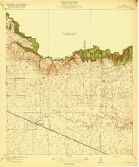 1920 Hockley1920 Print · USGSHarris County at the edge of the prairie reveals a landscape of early rail and timber industry just after the First World War. Trace local roots at Hockley and the Hegar School or locate the old Bauers Sawmill near Spring Creek.3 unique versions available
 - 1920 Map of Waller
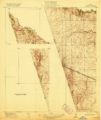 1920 Waller1920 Print · USGSThe Waller and Harris county line area comes into focus in this 1920s-era survey, detailing the early rail-and-road network. Genealogists and local historians can trace family sites like Badke Ranch, the Binford School, and the early layout of Waller.2 unique versions available
End of results
Showing maps 1-2 of 2
Top cities of Waller County
- Prairie View historical maps
- Hempstead historical maps
- Brookshire historical maps
- Pine Island historical maps
- Pattison historical maps
Frequently asked questions
- What are the different types of historical maps available for Waller County?
- What is the oldest map of Waller County?
- Where can I purchase historical maps of Waller County for my home or office?
- Where can I download high-res historical maps of Waller County?
- Are there historical topographic maps available for Waller County?
- Is there historical aerial imagery available for Waller County?
- Where are historical maps of Waller County sourced from?