1970s Maps of Waller County, Texas
Explore 6 historic maps of Waller County from the 1970s. These maps offer a rare glimpse into what life looked like during the 1970s — showing old roads, neighborhoods, homes, and landmarks that have changed or disappeared over time.
Whether you're researching your family's past, planning a metal detecting trip, or studying how Waller County's landscape evolved across the 1970s, these high-resolution maps are a powerful tool for exploring the history of this region.
- Focus on a specific era: All maps on this page are from the 1970s, giving you a focused view of this time period.
- See what’s changed: Compare century-old streets, trails, and buildings to today's modern landscape using overlays and satellite layers.
- Research with precision: Use these maps for genealogy, historical research, land use analysis, or educational projects.
- View, download, or print: Maps are fully viewable online in high resolution, and can be downloaded or printed for your own records.
Start exploring Waller County's history through authentic maps from the 1970s. This is your window into the past.
Waller County, TX maps
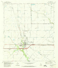
(6)- 1971 Map of Brookshire, 1973 Print
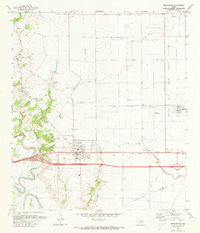 1971 Brookshire1973 Print · USGSThe towns of Brookshire and Pattison are shown here in the early seventies, caught between traditional rice farming and the expanding oil industry. Researchers can trace family sites like Wilpitz Cemetery or follow the Missouri Kansas Texas rail line through Cardiff.2 unique versions available
 - 1971 Map of Fulshear, 1973 Print
 1971 Fulshear1973 Print · USGSFulshear and Simonton appear in the early 1970s as the Southern Pacific railroad and the winding Brazos River shape the local landscape. Researchers can locate several community landmarks including Jerusalem Starlight Ch, Zion Chapel, and the Huntington Mound.2 unique versions available
 - 1971 Map of Hockley Mound, 1973 Print
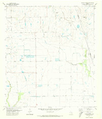 1971 Hockley Mound1973 Print · USGSThe Waller and Harris County borderlands appear in the early 1970s as a landscape of cattle ranching and petroleum production. Genealogists and historians can locate family burial sites at Frey Cemetery and trace the extent of the Katy Oil and Gas Field.3 unique versions available
 - 1971 Map of Warren Lake, 1974 Print
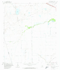 1971 Warren Lake1974 Print · USGSHarris County ranch land and prairie drainage are documented here in the early seventies, before suburban expansion reached these western reaches. Trace the Old Railroad Grade, explore the grounds of the Warren Ranch, and locate the Fish Hatchery along Cypress Creek.2 unique versions available
 - 1971 Map of Katy, 1974 Print
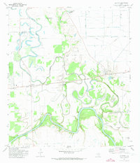
 1971 Katy1974 Print · USGSThe town of Katy and its surrounding oil fields are documented here in the early 1970s, showing a prairie landscape transitioning into an industrial and suburban hub. Genealogists and local historians can locate Magnolia Cem, Beckendorf, and the Odessa Kilpatrick Sch along the Missouri Kansas Texas rail line.3 unique versions available
 - 1975 Map of Houston, 1977 Print
 1975 Houston1977 Print · USGSThe Texas Gulf Coast in the mid-seventies shows a sprawling Houston metropolis linked to the sea by the massive Houston Ship Channel. Researchers can trace the mid-century industrial landscape from the Astrodome to the Lyndon B. Johnson Space Center.2 unique versions available
End of results
Showing maps 1-6 of 6
Top cities of Waller County
- Prairie View historical maps
- Hempstead historical maps
- Brookshire historical maps
- Pine Island historical maps
- Pattison historical maps
Frequently asked questions
- What are the different types of historical maps available for Waller County?
- What is the oldest map of Waller County?
- Where can I purchase historical maps of Waller County for my home or office?
- Where can I download high-res historical maps of Waller County?
- Are there historical topographic maps available for Waller County?
- Is there historical aerial imagery available for Waller County?
- Where are historical maps of Waller County sourced from?