1960s Maps of Pine Island, Texas
Explore 2 historic maps of Pine Island from the 1960s. These maps offer a rare glimpse into what life looked like during the 1960s — showing old roads, neighborhoods, homes, and landmarks that have changed or disappeared over time.
Whether you're researching your family's past, planning a metal detecting trip, or studying how Pine Island's landscape evolved across the 1960s, these high-resolution maps are a powerful tool for exploring the history of this region.
- Focus on a specific era: All maps on this page are from the 1960s, giving you a focused view of this time period.
- See what’s changed: Compare century-old streets, trails, and buildings to today's modern landscape using overlays and satellite layers.
- Research with precision: Use these maps for genealogy, historical research, land use analysis, or educational projects.
- View, download, or print: Maps are fully viewable online in high resolution, and can be downloaded or printed for your own records.
Start exploring Pine Island's history through authentic maps from the 1960s. This is your window into the past.
Pine Island, TX maps
(2)- 1960 Map of Waller, 1961 Print
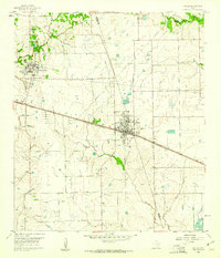 1960 Waller1961 Print · USGSThe Waller and Prairie View area at the dawn of the 1960s reveals a landscape of growing educational institutions and vital rail corridors. Researchers can trace the boundaries of Prairie View A & M College and locate family history at Waller Cem or Mathis Cem.4 unique versions available
 - 1961 Map of Hempstead, 1963 Print
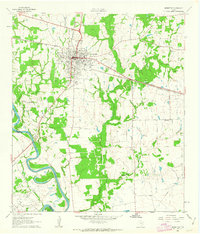 1961 Hempstead1963 Print · USGSHempstead and the surrounding Waller County prairie are captured here in the early sixties as a center of rail commerce and petroleum production. Genealogists can locate family landmarks such as Greater Wyatt Chapel, the Brenham Cem, and the Raccoon Bend Oil Field.4 unique versions available
End of results
Showing maps 1-2 of 2
Top cities near Pine Island
- Houston historical maps
- Katy historical maps
- Prairie View historical maps
- Hempstead historical maps
- Bellville historical maps
- Waller historical maps
See more
Frequently asked questions
- What are the different types of historical maps available for Pine Island?
- What is the oldest map of Pine Island?
- Where can I purchase historical maps of Pine Island for my home or office?
- Where can I download high-res historical maps of Pine Island?
- Are there historical topographic maps available for Pine Island?
- Is there historical aerial imagery available for Pine Island?
- Where are historical maps of Pine Island sourced from?