1970s Maps of Cashion Community, Texas
Explore 2 historic maps of Cashion Community from the 1970s. These maps offer a rare glimpse into what life looked like during the 1970s — showing old roads, neighborhoods, homes, and landmarks that have changed or disappeared over time.
Whether you're researching your family's past, planning a metal detecting trip, or studying how Cashion Community's landscape evolved across the 1970s, these high-resolution maps are a powerful tool for exploring the history of this region.
- Focus on a specific era: All maps on this page are from the 1970s, giving you a focused view of this time period.
- See what’s changed: Compare century-old streets, trails, and buildings to today's modern landscape using overlays and satellite layers.
- Research with precision: Use these maps for genealogy, historical research, land use analysis, or educational projects.
- View, download, or print: Maps are fully viewable online in high resolution, and can be downloaded or printed for your own records.
Start exploring Cashion Community's history through authentic maps from the 1970s. This is your window into the past.
Cashion Community, TX maps
(2)- 1972 Map of Burkburnett, 1975 Print
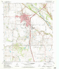 1972 Burkburnett1975 Print · USGSThe oil-rich plains of the Texas-Oklahoma border are captured here in the 1970s as the regional energy and military economy flourished. Researchers can trace the development of Burkburnett, locate old Oil Wells, and find landmarks like Hardin Sch or the Fish Hatchery.3 unique versions available
 - 1972 Map of Thornberry, 1975 Print
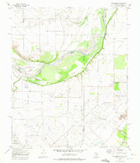 1972 Thornberry1975 Print · USGSThe Texas-Oklahoma borderlands in the early 1970s reveal an landscape defined by heavy industry and military presence. Researchers can trace the extensive Texhoma Oil Field, locate the Cem at Thornberry, or study the boundaries of Perkins Reservation.
End of results
Showing maps 1-2 of 2
Top cities near Cashion Community
- Wichita Falls historical maps
- Burkburnett historical maps
- Iowa Park historical maps
- Holliday historical maps
- Lakeside City historical maps
- Grandfield historical maps
See more
Frequently asked questions
- What are the different types of historical maps available for Cashion Community?
- What is the oldest map of Cashion Community?
- Where can I purchase historical maps of Cashion Community for my home or office?
- Where can I download high-res historical maps of Cashion Community?
- Are there historical topographic maps available for Cashion Community?
- Is there historical aerial imagery available for Cashion Community?
- Where are historical maps of Cashion Community sourced from?