1910s Maps of Wilbarger County, Texas
Explore 3 historic maps of Wilbarger County from the 1910s. These maps offer a rare glimpse into what life looked like during the 1910s — showing old roads, neighborhoods, homes, and landmarks that have changed or disappeared over time.
Whether you're researching your family's past, planning a metal detecting trip, or studying how Wilbarger County's landscape evolved across the 1910s, these high-resolution maps are a powerful tool for exploring the history of this region.
- Focus on a specific era: All maps on this page are from the 1910s, giving you a focused view of this time period.
- See what’s changed: Compare century-old streets, trails, and buildings to today's modern landscape using overlays and satellite layers.
- Research with precision: Use these maps for genealogy, historical research, land use analysis, or educational projects.
- View, download, or print: Maps are fully viewable online in high resolution, and can be downloaded or printed for your own records.
Start exploring Wilbarger County's history through authentic maps from the 1910s. This is your window into the past.
Wilbarger County, TX maps
(3)- 1916 Map of Electra, 1961 Print
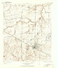 1916 Electra1961 Print · USGSElectra and the surrounding plains of North Texas are captured here just as the regional oil and rail economy was transforming the landscape. Genealogists and historians can trace the precise locations of the County Line School, Mt Carmel Church, and the Red River School.
 - 1917 Map of Beaver Creek, 1961 Print
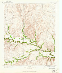 1917 Beaver Creek1961 Print · USGSNorth Texas at the end of the Great War was a landscape of remote schoolhouses and creekside chapels near the Wilbarger and Wichita county line. Researchers can locate early rural landmarks like Marvin Chapel, Ronda School, and the namesake Beaver Creek School.
 - 1918 Map of Electra
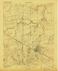 1918 Electra1918 Print · USGSThe North Texas plains near the Wichita-Wilbarger border show a growing network of roads and rural schools during the late nineteen-teens. Researchers can trace early family settlements and local landmarks like Mt Carmel Church, the Enterprise School, and the busy Electra townsite.
End of results
Showing maps 1-3 of 3
Top cities of Wilbarger County
Frequently asked questions
- What are the different types of historical maps available for Wilbarger County?
- What is the oldest map of Wilbarger County?
- Where can I purchase historical maps of Wilbarger County for my home or office?
- Where can I download high-res historical maps of Wilbarger County?
- Are there historical topographic maps available for Wilbarger County?
- Is there historical aerial imagery available for Wilbarger County?
- Where are historical maps of Wilbarger County sourced from?