1900s (20th Century) Maps of Vernon, Texas
Explore 6 historic maps of Vernon from the 1900s (20th Century). These maps offer a rare glimpse into what life looked like during the 1900s — showing old roads, neighborhoods, homes, and landmarks that have changed or disappeared over time.
Whether you're researching your family's past, planning a metal detecting trip, or studying how Vernon's landscape evolved across the 1900s, these high-resolution maps are a powerful tool for exploring the history of this region.
- Focus on a specific era: All maps on this page are from the 1900s, giving you a focused view of this time period.
- See what’s changed: Compare century-old streets, trails, and buildings to today's modern landscape using overlays and satellite layers.
- Research with precision: Use these maps for genealogy, historical research, land use analysis, or educational projects.
- View, download, or print: Maps are fully viewable online in high resolution, and can be downloaded or printed for your own records.
Start exploring Vernon's history through authentic maps from the 1900s. This is your window into the past.
Vernon, TX maps
(6)- 1955 Map of Lawton, 1958 Print
 1955 Lawton1958 Print · USGSSouthwestern Oklahoma and North Texas are shown here in the mid-fifties, dominated by the Wichita Mountains and the vital Red River watershed. Genealogists and historians can trace the foundations of Lawton alongside rural landmarks like Rainy Mountain Church and Pleasant Hill School.5 unique versions available
 - 1958 Map of Vernon, 1959 Print
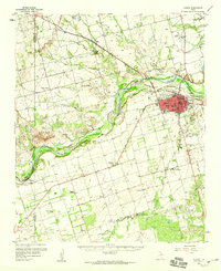 1958 Vernon1959 Print · USGSWilbarger County is captured in the late fifties as the local economy balanced ranching traditions with growing civic infrastructure. Researchers can locate family landmarks such as Lockett High Sch, the Santa Rosa Roundup Rodeo Grounds, and Pleasant Home Ch.2 unique versions available
 - 1983 Map of Lockett, 1984 Print
 1983 Lockett1984 Print · USGSWilbarger County comes to life in this early 1980s survey of the plains surrounding the county seat. Genealogists and local historians can trace the relationship between Lockett and Vernon, locating the Rodeo Ground, Hospital, and rural Cemetery plots.
 - 1983 Map of Vernon, 1984 Print
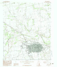 1983 Vernon1984 Print · USGSWilbarger County at the start of the 1980s reveals a well-developed regional hub centered on the city of Vernon. Researchers can trace the layout of Vernon Regional Junior College and find local landmarks like the Drive-In Theater and the community of Paradise.
 - 1986 Map of Vernon
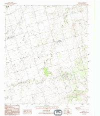
 1986 Vernon1986 Print · USGSNorth Texas and Southern Oklahoma meet along the river in the mid-1980s, revealing a landscape defined by ranching, oil production, and rail transport. Researchers can locate distinct landmarks such as Medicine Mound, the Conley Oil Field, and the community of Punkin Center.
 - 1990 Map of Lockett, 1995 Print
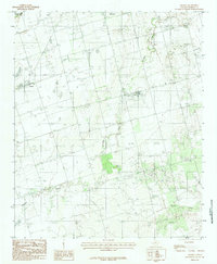
 1990 Lockett1995 Print · USGSThe rural plains of Wilbarger County are documented here in the early nineties, centered on the community of Lockett. Researchers can trace local landmarks like the Cemetery, follow the winding path of Paradise Creek, or locate the Rodeo Ground.
End of results
Showing maps 1-6 of 6
Top cities near Vernon
Frequently asked questions
- What are the different types of historical maps available for Vernon?
- What is the oldest map of Vernon?
- Where can I purchase historical maps of Vernon for my home or office?
- Where can I download high-res historical maps of Vernon?
- Are there historical topographic maps available for Vernon?
- Is there historical aerial imagery available for Vernon?
- Where are historical maps of Vernon sourced from?