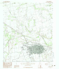
1983 Map of Vernon
USGS Topo · Published 1984About this map
Vernon serves as the focal point of this North Texas study, positioned at the confluence of several key waterways and transportation routes. The landscape is defined by the Pease River and its tributaries, including Wildcat Creek, Boggy Creek, and Elizabeth Dan Creek. The 1980s layout of the town shows a mix of educational and recreational development, anchored by the Vernon Regional Junior College and a sprawling Golf Course to the west.
Find a feature on this map
16 named features on this map. Tap any name to fly to it.
Don’t see what you’re looking for? This feature index may not catch every label — zoom into the map to look around manually.
Map Details
Editions of this 1983 Vernon Map
This is the sole edition of this map. No revisions or reprints were ever made.
Other maps of this area

1955 · Lawton
USGS Topo · 1:250,000

1958 · Davidson
USGS Topo · 1:62,500

1958 · Frederick
USGS Topo · 1:62,500

1958 · Vernon
USGS Topo · 1:62,500

1958 · Elmer
USGS Topo · 1:62,500

1975 · Frederick SW
USGS Topo · 1:24,000
1983 · Boggy Creek
USGS Topo · 1:24,000

1983 · Tolbert
USGS Topo · 1:24,000
1983 · Rayland
USGS Topo · 1:24,000
1983 · Lockett
USGS Topo · 1:24,000