1930s Maps of Willacy County, Texas
Explore 5 historic maps of Willacy County from the 1930s. These maps offer a rare glimpse into what life looked like during the 1930s — showing old roads, neighborhoods, homes, and landmarks that have changed or disappeared over time.
Whether you're researching your family's past, planning a metal detecting trip, or studying how Willacy County's landscape evolved across the 1930s, these high-resolution maps are a powerful tool for exploring the history of this region.
- Focus on a specific era: All maps on this page are from the 1930s, giving you a focused view of this time period.
- See what’s changed: Compare century-old streets, trails, and buildings to today's modern landscape using overlays and satellite layers.
- Research with precision: Use these maps for genealogy, historical research, land use analysis, or educational projects.
- View, download, or print: Maps are fully viewable online in high resolution, and can be downloaded or printed for your own records.
Start exploring Willacy County's history through authentic maps from the 1930s. This is your window into the past.
Willacy County, TX maps
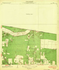
(5)- 1930 Map of La Leona
 1930 La Leona1930 Print · USGSCoastal Texas ranching and tidal waterways are frozen in time during this pre-war survey of the Rio Grande Valley. Genealogists and historians can trace the footprint of early holdings like La Leona Ranch and Los Coyotes Ranch along the Arroyo Colorado.
 - 1932 Map of Combes
 1932 Combes1932 Print · USGSThe lower Rio Grande Valley comes into focus in the early 1930s, showing a landscape of family ranches and new flood control infrastructure. Genealogists and historians can trace the Missouri Pacific No 96 rail line through Combes and find rural landmarks like Briggs Coleman Sch and La India Ranch.2 unique versions available
 - 1933 Map of Santa Rosa
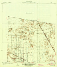 1933 Santa Rosa1933 Print · USGSThe Rio Grande Valley landscape comes into focus in the early thirties as irrigation and flood control reshape the coastal plain. Researchers can trace the footprints of family estates like Santa Rita Ranch and the vital paths of the Missouri Pacific railroad.3 unique versions available
 - 1933 Map of Paso Real
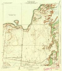
 1933 Paso Real1933 Print · USGSDeep in the Rio Grande Valley in the early 1930s, this area shows a landscape shaped by the Arroyo Colorado. Genealogists and historians can trace the Ferry at Paso Real, the Missouri Pacific railroad line, and old settlements like Fernando.2 unique versions available
 - 1936 Map of La Leona
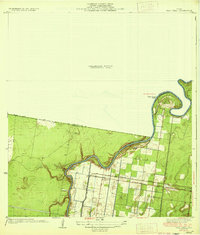
 1936 La Leona1936 Print · USGSCoastal Cameron County was a land of sprawling ranch outposts and tidal waterways in the mid-1930s. Genealogists and historians can trace family landholdings at Boca Chica Ranch or La Leona and follow the old Missouri Pacific rail corridor.3 unique versions available
End of results
Showing maps 1-5 of 5
Top cities of Willacy County
- Raymondville historical maps
- Lyford historical maps
- Sebastian historical maps
- Lasara historical maps
- San Perlita historical maps
- Port Mansfield historical maps
Frequently asked questions
- What are the different types of historical maps available for Willacy County?
- What is the oldest map of Willacy County?
- Where can I purchase historical maps of Willacy County for my home or office?
- Where can I download high-res historical maps of Willacy County?
- Are there historical topographic maps available for Willacy County?
- Is there historical aerial imagery available for Willacy County?
- Where are historical maps of Willacy County sourced from?