1960s Maps of Willacy County, Texas
Explore 3 historic maps of Willacy County from the 1960s. These maps offer a rare glimpse into what life looked like during the 1960s — showing old roads, neighborhoods, homes, and landmarks that have changed or disappeared over time.
Whether you're researching your family's past, planning a metal detecting trip, or studying how Willacy County's landscape evolved across the 1960s, these high-resolution maps are a powerful tool for exploring the history of this region.
- Focus on a specific era: All maps on this page are from the 1960s, giving you a focused view of this time period.
- See what’s changed: Compare century-old streets, trails, and buildings to today's modern landscape using overlays and satellite layers.
- Research with precision: Use these maps for genealogy, historical research, land use analysis, or educational projects.
- View, download, or print: Maps are fully viewable online in high resolution, and can be downloaded or printed for your own records.
Start exploring Willacy County's history through authentic maps from the 1960s. This is your window into the past.
Willacy County, TX maps
(3)- 1962 Map of Brownsville
 1962 Brownsville1962 Print · USGSThe Lower Rio Grande Valley in the early sixties was a landscape of coastal wildlands, booming oil fields, and international border commerce. Trace the development of this frontier region through landmarks like Harlingen Air Force Base, Boca Chica Island, and the Willamar Oil Field.
 - 1962 Map of McAllen
 1962 McAllen1962 Print · USGSThe Lower Rio Grande Valley in the mid-twentieth century shows a complex landscape of irrigation, oil production, and border commerce. Genealogists and historians can trace family roots through riverside towns like Zapata, Roma-Los Saenz, and Hidalgo, or locate landmarks like Santa Elena Ch and Moore Air Force Base.
 - 1963 Map of Hargill, 1965 Print
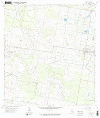 1963 Hargill1965 Print · USGSHargill and the surrounding Rio Grande Valley were defined by gas production and industrial irrigation in the early 1960s. Genealogists can locate family landmarks like Cibilo Cem and La Coma Ranch or trace the Missouri Pacific rail line.2 unique versions available
End of results
Showing maps 1-3 of 3
Top cities of Willacy County
- Raymondville historical maps
- Lyford historical maps
- Sebastian historical maps
- Lasara historical maps
- San Perlita historical maps
- Port Mansfield historical maps
Frequently asked questions
- What are the different types of historical maps available for Willacy County?
- What is the oldest map of Willacy County?
- Where can I purchase historical maps of Willacy County for my home or office?
- Where can I download high-res historical maps of Willacy County?
- Are there historical topographic maps available for Willacy County?
- Is there historical aerial imagery available for Willacy County?
- Where are historical maps of Willacy County sourced from?