1920s Maps of Monadale, Texas
Explore 2 historic maps of Monadale from the 1920s. These maps offer a rare glimpse into what life looked like during the 1920s — showing old roads, neighborhoods, homes, and landmarks that have changed or disappeared over time.
Whether you're researching your family's past, planning a metal detecting trip, or studying how Monadale's landscape evolved across the 1920s, these high-resolution maps are a powerful tool for exploring the history of this region.
- Focus on a specific era: All maps on this page are from the 1920s, giving you a focused view of this time period.
- See what’s changed: Compare century-old streets, trails, and buildings to today's modern landscape using overlays and satellite layers.
- Research with precision: Use these maps for genealogy, historical research, land use analysis, or educational projects.
- View, download, or print: Maps are fully viewable online in high resolution, and can be downloaded or printed for your own records.
Start exploring Monadale's history through authentic maps from the 1920s. This is your window into the past.
Monadale, TX maps
(2)- 1925 Map of Georgetown 4-d
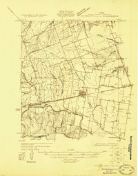 1925 Georgetown 4-d1925 Print · USGSWilliamson County in the mid-1920s shows a landscape of developing prairie towns and rural cotton gins. Genealogists can trace early homesteads and landmarks like Stony Point School, Bell Gin, and the historic Hutto townsite.
 - 1928 Map of Round Rock
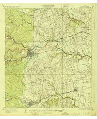 1928 Round Rock1928 Print · USGSWilliamson County in the mid-twenties shows a landscape of developing rail hubs and scattered rural school districts. Genealogists can locate family landmarks like Bell Gin, Old Round Rock, and the Strickland Grove Church.2 unique versions available
End of results
Showing maps 1-2 of 2
Top cities near Monadale
- Austin historical maps
- Round Rock historical maps
- Georgetown historical maps
- Pflugerville historical maps
- Cedar Park historical maps
- Hutto historical maps
See more
Frequently asked questions
- What are the different types of historical maps available for Monadale?
- What is the oldest map of Monadale?
- Where can I purchase historical maps of Monadale for my home or office?
- Where can I download high-res historical maps of Monadale?
- Are there historical topographic maps available for Monadale?
- Is there historical aerial imagery available for Monadale?
- Where are historical maps of Monadale sourced from?