1960s Maps of Schwertner, Texas
Explore 1 historic maps of Schwertner from the 1960s. These maps offer a rare glimpse into what life looked like during the 1960s — showing old roads, neighborhoods, homes, and landmarks that have changed or disappeared over time.
Whether you're researching your family's past, planning a metal detecting trip, or studying how Schwertner's landscape evolved across the 1960s, these high-resolution maps are a powerful tool for exploring the history of this region.
- Focus on a specific era: All maps on this page are from the 1960s, giving you a focused view of this time period.
- See what’s changed: Compare century-old streets, trails, and buildings to today's modern landscape using overlays and satellite layers.
- Research with precision: Use these maps for genealogy, historical research, land use analysis, or educational projects.
- View, download, or print: Maps are fully viewable online in high resolution, and can be downloaded or printed for your own records.
Start exploring Schwertner's history through authentic maps from the 1960s. This is your window into the past.
Schwertner, TX maps
(1)- 1964 Map of Jarrell, 1966 Print
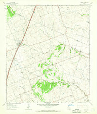 1964 Jarrell1966 Print · USGSJarrell and the surrounding Williamson County farmland are captured here in the mid-1960s as Interstate 35 began to shape the corridor. Genealogists can locate family landmarks like Corn Hill Cem, Holy Trinity Sch, and the small settlement of Theon.
End of results
Showing maps 1-1 of 1
Top cities near Schwertner
- Killeen historical maps
- Round Rock historical maps
- Temple historical maps
- Georgetown historical maps
- Harker Heights historical maps
- Hutto historical maps
See more
Frequently asked questions
- What are the different types of historical maps available for Schwertner?
- What is the oldest map of Schwertner?
- Where can I purchase historical maps of Schwertner for my home or office?
- Where can I download high-res historical maps of Schwertner?
- Are there historical topographic maps available for Schwertner?
- Is there historical aerial imagery available for Schwertner?
- Where are historical maps of Schwertner sourced from?