1960s Maps of Newark, Texas
Explore 2 historic maps of Newark from the 1960s. These maps offer a rare glimpse into what life looked like during the 1960s — showing old roads, neighborhoods, homes, and landmarks that have changed or disappeared over time.
Whether you're researching your family's past, planning a metal detecting trip, or studying how Newark's landscape evolved across the 1960s, these high-resolution maps are a powerful tool for exploring the history of this region.
- Focus on a specific era: All maps on this page are from the 1960s, giving you a focused view of this time period.
- See what’s changed: Compare century-old streets, trails, and buildings to today's modern landscape using overlays and satellite layers.
- Research with precision: Use these maps for genealogy, historical research, land use analysis, or educational projects.
- View, download, or print: Maps are fully viewable online in high resolution, and can be downloaded or printed for your own records.
Start exploring Newark's history through authentic maps from the 1960s. This is your window into the past.
Newark, TX maps
(2)- 1960 Map of Boyd, 1961 Print
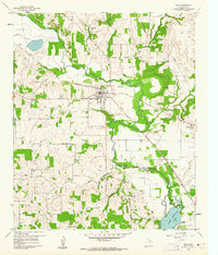 1960 Boyd1961 Print · USGSWise County's river-and-rail corridor is captured here in the early sixties, centered on the town of Boyd. Genealogists and historians can locate numerous family-named burial sites like Arkansas Cem and Stoker Cem, or trace the winding West Fork Trinity River.3 unique versions available
 - 1960 Map of Rhome, 1961 Print
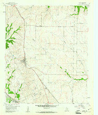 1960 Rhome1961 Print · USGSWise County cattle country and rail junctions are documented here at the start of the sixties. You can trace the path of the FORT WORTH AND DENVER through Rhome or locate family sites like Fairview Ch and Aurora Cem.3 unique versions available
End of results
Showing maps 1-2 of 2
Top cities near Newark
- Fort Worth historical maps
- Denton historical maps
- North Richland Hills historical maps
- Keller historical maps
- Haltom City historical maps
- Weatherford historical maps
See more
Frequently asked questions
- What are the different types of historical maps available for Newark?
- What is the oldest map of Newark?
- Where can I purchase historical maps of Newark for my home or office?
- Where can I download high-res historical maps of Newark?
- Are there historical topographic maps available for Newark?
- Is there historical aerial imagery available for Newark?
- Where are historical maps of Newark sourced from?