1900s (20th Century) Maps of Young County, Texas
Explore 41 historic maps of Young County from the 1900s (20th Century). These maps offer a rare glimpse into what life looked like during the 1900s — showing old roads, neighborhoods, homes, and landmarks that have changed or disappeared over time.
Whether you're researching your family's past, planning a metal detecting trip, or studying how Young County's landscape evolved across the 1900s, these high-resolution maps are a powerful tool for exploring the history of this region.
- Focus on a specific era: All maps on this page are from the 1900s, giving you a focused view of this time period.
- See what’s changed: Compare century-old streets, trails, and buildings to today's modern landscape using overlays and satellite layers.
- Research with precision: Use these maps for genealogy, historical research, land use analysis, or educational projects.
- View, download, or print: Maps are fully viewable online in high resolution, and can be downloaded or printed for your own records.
Start exploring Young County's history through authentic maps from the 1900s. This is your window into the past.
Young County, TX maps
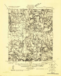
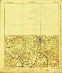
(41)- 1918 Map of Palo Pinto
 1918 Palo Pinto1918 Print · USGSPalo Pinto County and the Brazos River valley appear here in the final year of the Great War, showing a landscape shaped by coal and steam. Genealogists and historians can locate defunct river crossings like Oaks Ferry, early rural education at Marsden School, and the extensive Coal Mines that once powered the regional economy.
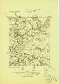
 - 1924 Map of Breckenridge 1-a
 1924 Breckenridge 1-a1924 Print · USGSNorth Central Texas oil and ranching lands are captured here in the mid-1920s at the junction of three counties. Genealogists can locate family homesteads near Eliasville PO, Sorghum Flat School, or the petroleum derricks at Eubanks Derrick.
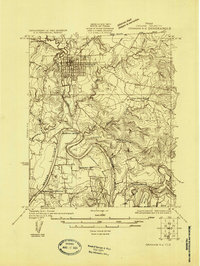
 - 1924 Map of Palo Pinto 2-b
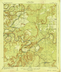
 1924 Palo Pinto 2-b1924 Print · USGSThe Brazos River winds through Palo Pinto and Young counties in the mid-twenties, long before the creation of modern reservoirs. Researchers can locate the Pickwick settlement, several river transits like Wild Bend Crossing, and the McAdams Cem.
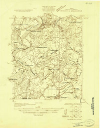
 - 1924 Map of Graham 4-d
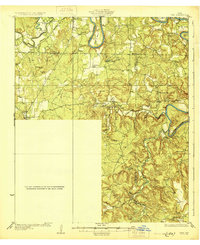
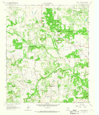
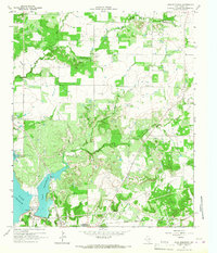
 1924 Graham 4-d1924 Print · USGSYoung County in the 1920s is defined by the winding Brazos River and the growing railroad hub of Graham. Researchers can trace rural life through the locations of Flat Rock School, the Gooseneck Cem, and river crossings like the Toll Bridge.
 - 1925 Map of Graham 4-c
 1925 Graham 4-c1925 Print · USGSYoung County in the 1920s shows a landscape of small rural communities and historic river fords before the expansion of modern highways. Local historians can trace early school sites like Como School and Upper Tonk School or follow the route of the Old Military Road.
 - 1925 Map of Breckenridge 1-b
 1925 Breckenridge 1-b1925 Print · USGSThe Brazos River valley at the Stephens and Young county line comes to life in this mid-1920s survey. Genealogists and local historians can trace the rural landscape through the locations of Lone Star School, the settlement of Ivan, and the Wichita Southern rail line.
 - 1927 Map of Graham
 1927 Graham1927 Print · USGSYoung County's river-driven landscape comes alive in this mid-1920s survey of the Brazos River and its many bends. Genealogists can trace early rural life through Medlin Chapel, Gooseneck Cem, and several local schools like Mt Pleasant School.2 unique versions available
 - 1927 Map of Pickwick
 1927 Pickwick1927 Print · USGSThe Brazos River loops through Palo Pinto and Young Counties in the mid-1920s, showing the river's path before the dams. Genealogists can trace family landmarks like Mc Adams Cem, Henry Chapel, and the isolated Belding Ranch.2 unique versions available
 - 1931 Map of Ivan
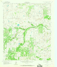
 1931 Ivan1931 Print · USGSThe Brazos River loop and the rolling breaks of north-central Texas are captured here in the mid-1920s. Genealogists can locate family-named schoolhouses and small settlements like Duff Prairie Sch, South Bend, and Oil City.2 unique versions available
 - 1954 Map of Abilene, 1966 Print
 1954 Abilene1966 Print · USGSThe Texas Big Country comes into focus in the mid-1950s as petroleum and new water projects reshape the landscape. Local historians can trace the Butterfield Trail, find the Fort Phantom Hill Ruins, and locate numerous small communities along the Texas & Pacific line.2 unique versions available
 - 1954 Map of Wichita Falls, 1966 Print
 1954 Wichita Falls1966 Print · USGSNorth Texas in the mid-fifties is captured here as a landscape of expanding oil fields and vital rail corridors. Genealogists and historians can trace family roots through rural landmarks like Bacon Chapel and the rail-side growth of Seymour and Archer City.3 unique versions available
 - 1958 Map of Wichita Falls
 1958 Wichita Falls1958 Print · USGSNorth Texas during the late fifties reveals a landscape defined by the booming petroleum industry and established rail hubs. Researchers can trace the development of Wichita Falls and discover rural landmarks like Barton's Chapel or the Hull-Silk Oil Field.
 - 1958 Map of Abilene
 1958 Abilene1958 Print · USGSMid-century West Texas comes alive in this survey of the Abilene and Stephenville region during a period of steady oil expansion and military growth. Genealogists and local historians can trace the paths of the Texas & Pacific RR through historic towns, locate the Fort Griffin Ruins, and find smaller settlements like Desdemona and Lueders.
 - 1958 Map of Palo Pinto, 1960 Print
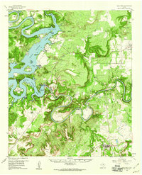 1958 Palo Pinto1960 Print · USGSThe Palo Pinto Mountains and the winding Brazos River are captured here in the late fifties, just as Possum Kingdom Lake was maturing into a regional landmark. Researchers can trace family history at Mc Adams Cem, explore the Floyd Dalton Oil Field, or locate Palo Pinto and Graford.2 unique versions available
 - 1963 Map of Megargel, 1967 Print
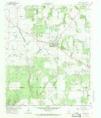 1963 Megargel1967 Print · USGSMegargel was a bustling center of oil production and rural life in North Texas during the early sixties. Genealogists and historians can locate the High Sch, the local PO, and numerous Oil Wells scattered along Kickapoo Creek.
 - 1964 Map of Newcastle, 1967 Print
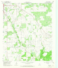
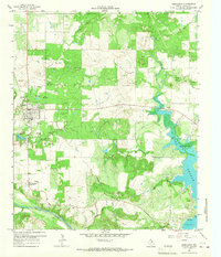 1964 Newcastle1967 Print · USGSIn the mid-1960s, the Newcastle area of Young County balanced its frontier roots with a busy coal and oil economy. Researchers can trace the legacy of the Old Military Grade or locate family sites at Belknap Cem and Wray Cem.2 unique versions available
 - 1964 Map of Bobcat Bluff, 1967 Print
 1964 Bobcat Bluff1967 Print · USGSArcher County at the height of the mid-century oil boom reveals a landscape of industrial development and river drainage. Trace the Old Railroad Grade past the Anarene Oil Field and the headwaters of the West Fork Trinity River.
 - 1964 Map of Padgett, 1967 Print
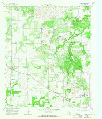
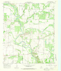 1964 Padgett1967 Print · USGSYoung and Throckmorton Counties are captured in the mid-sixties as the winding Brazos River carves through the central plains. Genealogists and researchers can locate family sites at Padgett Cem and Reynolds Cem or trace the early oil economy at Daniels.2 unique versions available
 - 1964 Map of Darnell Branch, 1967 Print
 1964 Darnell Branch1967 Print · USGSIn the early 1960s, the North Texas prairie here was a landscape of ranching and oil extraction at the meeting of four counties. Researchers can trace the winding West Fork Trinity River and locate energy landmarks like Burns-Jones Field or Spy Knob.
 - 1964 Map of True, 1967 Print
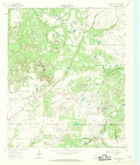
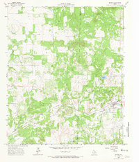
 1964 True1967 Print · USGSYoung County's oil-rich landscape is documented here in the early 1960s, showing the intersection of rural life and industrial growth. Researchers can trace family sites at True Cem and Pleasant Valley Ch or locate the town of Olney and its Drive-in Theater.2 unique versions available
 - 1964 Map of Loving, 1967 Print
 1964 Loving1967 Print · USGSYoung County in the early 1960s is characterized by its emerging energy landscape and small rural hubs. Trace the local petroleum infrastructure from the Refinery to the Ligon Oil Field and find family roots at Hawkins Chapel Cem or in the town of Loving.2 unique versions available
 - 1964 Map of Bryson, 1967 Print
 1964 Bryson1967 Print · USGSBryson and the surrounding North Texas oil country are documented here in the early sixties. Researchers can trace the Chicago Rock Island and Pacific rail line through town to find the local Refinery, High Sch, and nearby Rock Creek Cem.2 unique versions available
 - 1964 Map of Lake Eddleman, 1967 Print
 1964 Lake Eddleman1967 Print · USGSYoung County, Texas, was a landscape defined by oil production and new reservoirs in the 1960s. Genealogists and historians can trace family locations near Red Top, the Community Center Cem, and the massive Ligon Oil Field.2 unique versions available
 - 1964 Map of Prickly Pear Branch, 1967 Print
 1964 Prickly Pear Branch1967 Print · USGSTexas ranchlands and petroleum country meet in the 1960s along the Archer Co and Young Co line. Trace the 20th-century energy landscape through a dense Oil Field and its many Oil Wells bordering the West Fork Trinity River.2 unique versions available
 - 1964 Map of Lake Olney, 1967 Print
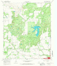 1964 Lake Olney1967 Print · USGSArcher and Young counties in the mid-1960s show a North Texas landscape shaped by oil production and reservoir expansion. Researchers can trace rural genealogy at St Luke Cem or explore the mid-century infrastructure of Lake Olney and the surrounding oil fields.
Showing maps 1-25 of 41
Top cities of Young County
Frequently asked questions
- What are the different types of historical maps available for Young County?
- What is the oldest map of Young County?
- Where can I purchase historical maps of Young County for my home or office?
- Where can I download high-res historical maps of Young County?
- Are there historical topographic maps available for Young County?
- Is there historical aerial imagery available for Young County?
- Where are historical maps of Young County sourced from?