1980s Maps of Beaver, Utah
Explore 3 historic maps of Beaver from the 1980s. These maps offer a rare glimpse into what life looked like during the 1980s — showing old roads, neighborhoods, homes, and landmarks that have changed or disappeared over time.
Whether you're researching your family's past, planning a metal detecting trip, or studying how Beaver's landscape evolved across the 1980s, these high-resolution maps are a powerful tool for exploring the history of this region.
- Focus on a specific era: All maps on this page are from the 1980s, giving you a focused view of this time period.
- See what’s changed: Compare century-old streets, trails, and buildings to today's modern landscape using overlays and satellite layers.
- Research with precision: Use these maps for genealogy, historical research, land use analysis, or educational projects.
- View, download, or print: Maps are fully viewable online in high resolution, and can be downloaded or printed for your own records.
Start exploring Beaver's history through authentic maps from the 1980s. This is your window into the past.
Beaver, UT maps
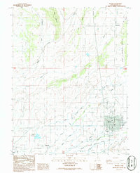
(3)- 1980 Map of Beaver, 1981 Print
 1980 Beaver1981 Print · USGSSouthern Utah at the start of the 1980s reveals a rugged landscape of high mountain plateaus and essential desert irrigation networks. Researchers can trace the path of the Denver and Rio Grande Western through Marysvale or locate local landmarks like the Deer Trail Mine and Puffer Lake.2 unique versions available
 - 1986 Map of Beaver
 1986 Beaver1986 Print · USGSBeaver County is captured in the mid-1980s as a thriving agricultural hub centered on the river valley. Genealogists and local historians can trace the irrigation networks of Carter Ditch and locate family landmarks from Manderfield to Greenville.
 - 1987 Map of Black Ridge
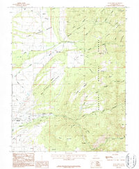 1987 Black Ridge1987 Print · USGSBeaver, Utah, is documented here in the late eighties, showing the critical intersection of mountain water and valley agriculture. Genealogists and local historians can trace irrigation networks like the South Field DITCH and explore landmarks from Rattlesnake Peak to Ponderosa Park.
End of results
Showing maps 1-3 of 3
Frequently asked questions
- What are the different types of historical maps available for Beaver?
- What is the oldest map of Beaver?
- Where can I purchase historical maps of Beaver for my home or office?
- Where can I download high-res historical maps of Beaver?
- Are there historical topographic maps available for Beaver?
- Is there historical aerial imagery available for Beaver?
- Where are historical maps of Beaver sourced from?