1900s (20th Century) Maps of Boulder, Utah
Explore 5 historic maps of Boulder from the 1900s (20th Century). These maps offer a rare glimpse into what life looked like during the 1900s — showing old roads, neighborhoods, homes, and landmarks that have changed or disappeared over time.
Whether you're researching your family's past, planning a metal detecting trip, or studying how Boulder's landscape evolved across the 1900s, these high-resolution maps are a powerful tool for exploring the history of this region.
- Focus on a specific era: All maps on this page are from the 1900s, giving you a focused view of this time period.
- See what’s changed: Compare century-old streets, trails, and buildings to today's modern landscape using overlays and satellite layers.
- Research with precision: Use these maps for genealogy, historical research, land use analysis, or educational projects.
- View, download, or print: Maps are fully viewable online in high resolution, and can be downloaded or printed for your own records.
Start exploring Boulder's history through authentic maps from the 1900s. This is your window into the past.
Boulder, UT maps
(5)- 1956 Map of Escalante
 1956 Escalante1956 Print · USGSSouthern Utah and Northern Arizona are charted here in the mid-fifties, just before the canyon floor was transformed. Researchers can trace remote desert commerce at Oljeto Trading Post, find the Adairville (ruins), and locate Uranium mines.5 unique versions available
 - 1960 Map of Escalante
 1960 Escalante1960 Print · USGSSouthern Utah and northern Arizona appear at a historic turning point in the late fifties as Lake Powell begins to reshape the canyons. Researchers can trace remote sites like Goulding Trading Post, a lonely Uranium Mine, and Coyote Ranches before the reservoir's rise.
 - 1964 Map of Calf Creek, 1966 Print
 1964 Calf Creek1966 Print · USGSCentral Utah in the mid-1960s reveals a wild landscape of arches and deep canyons. Trace geological wonders and early trails like Escalante Natural Bridge, Phipps Arch, and the remote McGath Trail.5 unique versions available
 - 1964 Map of Boulder Town, 1973 Print
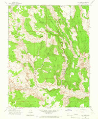
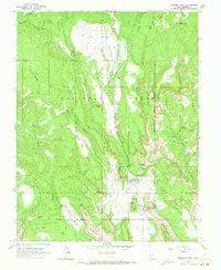 1964 Boulder Town1973 Print · USGSBoulder Town and the high benches of the Dixie National Forest are captured here in the mid-1960s. Genealogists and researchers can locate the Boulder Post Office, the Boulder Landing Strip, and early local sites like the Rodeo Grounds.4 unique versions available
 - 1980 Map of Escalante, 1988 Print
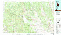 1980 Escalante1988 Print · USGSThe high desert and canyonlands of southern Utah are shown here in the 1980s, centered on the settlement of Escalante. Researchers can trace the ranching and resource history of Johns Valley or the early boundaries of Capitol Reef National Park.3 unique versions available
End of results
Showing maps 1-5 of 5
Top cities near Boulder
Frequently asked questions
- What are the different types of historical maps available for Boulder?
- What is the oldest map of Boulder?
- Where can I purchase historical maps of Boulder for my home or office?
- Where can I download high-res historical maps of Boulder?
- Are there historical topographic maps available for Boulder?
- Is there historical aerial imagery available for Boulder?
- Where are historical maps of Boulder sourced from?