Old Maps of Eggnog, Utah for Genealogy
Trace your family roots with 9 historic maps of Eggnog. These high-res maps reveal old neighborhoods, homesites, landmarks, and streets — helping you uncover where your ancestors lived and how the area evolved over time.
- Explore historic neighborhoods: Identify where your relatives may have lived in the 1800s or 1900s.
- Compare maps over time: Trace the changes in streets, buildings, and landmarks for multi-generational research.
- Perfect for genealogy & ancestry research: Used by family historians and researchers to map out lineage and migration.
These maps are an incredible resource for exploring your personal connection to Eggnog's past.
Eggnog, UT maps
(9)- 1886 Map of Henry Mountains
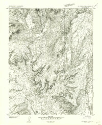
 1886 Henry Mountains1886 Print · USGSSouthern Utah remains a wilderness of deep canyons and volcanic peaks in this 1880s survey. Researchers can trace the original courses of the Colorado River through Cataract Canyon and find landmarks like Navajo Mt and Monument Valley.
 - 1892 Map of Henry Mountains
 1892 Henry Mountains1892 Print · USGSSouthern Utah in the late 1800s remains a wilderness of deep canyons and isolated peaks under the direction of J.W. Powell. Geologists and historians can trace the geological spine of the Water Pocket Fold and the early boundaries of the Navajo Indian Res. near Monument Valley.6 unique versions available
 - 1953 Map of Mt Pennell
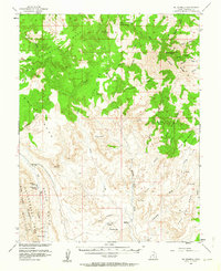 1953 Mt Pennell1953 Print · USGSThe Henry Mountains and the Waterpocket Fold dominate this mid-century survey of the Utah desert. Researchers can trace the remote Stanton Mine, find water at Muley Tanks, and locate the oddly-named Eggnog camp.3 unique versions available
 - 1953 Map of Mt Pennell 2 SE, 1954 Print
 1953 Mt Pennell 2 SE1954 Print · USGSGarfield County is captured in the early fifties as the search for mineral wealth shaped the high desert terrain. Local history researchers can trace the location of Stanton Mine and isolate isolated water sources like Jackass Spring and Pennell Creek.
 - 1956 Map of Escalante
 1956 Escalante1956 Print · USGSSouthern Utah and Northern Arizona are charted here in the mid-fifties, just before the canyon floor was transformed. Researchers can trace remote desert commerce at Oljeto Trading Post, find the Adairville (ruins), and locate Uranium mines.5 unique versions available
 - 1960 Map of Escalante
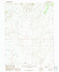
 1960 Escalante1960 Print · USGSSouthern Utah and northern Arizona appear at a historic turning point in the late fifties as Lake Powell begins to reshape the canyons. Researchers can trace remote sites like Goulding Trading Post, a lonely Uranium Mine, and Coyote Ranches before the reservoir's rise.
 - 1980 Map of Hite Crossing, 1987 Print
 1980 Hite Crossing1987 Print · USGSSouthern Utah's canyon country comes alive in the early eighties as the waters of Lake Powell reshape the landscape. Trace old mining operations like the Happy Jack Mine or the remote peaks of the Henry Mountains.
 - 1987 Map of Ant Knoll
 1987 Ant Knoll1987 Print · USGSGarfield County's high-desert plateaus are captured here in the late eighties, showing a landscape defined by dramatic mesa and bench formations. Researchers can trace the path of the Hoskinnini Road or locate water sources like Eggnog Spring and Saleratus Spring.
 - 2023 Map of Ant Knoll, 2023 Print
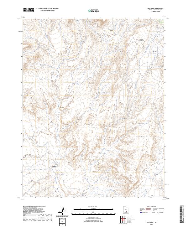 2023 Ant Knoll2023 Print · USGSGarfield County's high-desert plateaus are captured here in the early twenty-first century, showing the intersection of remote settlement and natural landforms. Genealogists and desert explorers can trace the area around Eggnog or locate landmarks like Jackass Spring and Coal Bed Mesa.
End of results
Showing maps 1-9 of 9
Frequently asked questions
- What are the different types of historical maps available for Eggnog?
- What is the oldest map of Eggnog?
- Where can I purchase historical maps of Eggnog for my home or office?
- Where can I download high-res historical maps of Eggnog?
- Are there historical topographic maps available for Eggnog?
- Is there historical aerial imagery available for Eggnog?
- Where are historical maps of Eggnog sourced from?