1980s Maps of Panguitch Lake Resort, Utah
Explore 2 historic maps of Panguitch Lake Resort from the 1980s. These maps offer a rare glimpse into what life looked like during the 1980s — showing old roads, neighborhoods, homes, and landmarks that have changed or disappeared over time.
Whether you're researching your family's past, planning a metal detecting trip, or studying how Panguitch Lake Resort's landscape evolved across the 1980s, these high-resolution maps are a powerful tool for exploring the history of this region.
- Focus on a specific era: All maps on this page are from the 1980s, giving you a focused view of this time period.
- See what’s changed: Compare century-old streets, trails, and buildings to today's modern landscape using overlays and satellite layers.
- Research with precision: Use these maps for genealogy, historical research, land use analysis, or educational projects.
- View, download, or print: Maps are fully viewable online in high resolution, and can be downloaded or printed for your own records.
Start exploring Panguitch Lake Resort's history through authentic maps from the 1980s. This is your window into the past.
Panguitch Lake Resort, UT maps
(2)- 1980 Map of Panguitch, 1981 Print
 1980 Panguitch1981 Print · USGSThe high plateau country of Southern Utah is captured here in the early eighties, centered on the Sevier River and the gateway town of Panguitch. Researchers can trace the boundaries of Bryce Canyon National Park and find local landmarks like Ruby's Inn, Panguitch Lake, and Hatch.2 unique versions available
 - 1985 Map of Panguitch Lake
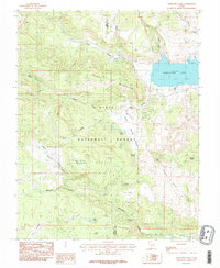 1985 Panguitch Lake1985 Print · USGSSouthern Utah's high-elevation lake country is captured in the mid-eighties as a hub for forest recreation and ranching. Trace the development of Panguitch Lake and find remote landmarks like John L Flat, Miller Knoll, and Mammoth Spring.2 unique versions available
End of results
Showing maps 1-2 of 2
Top cities near Panguitch Lake Resort
- Parowan historical maps
- Panguitch historical maps
- Paragonah historical maps
- Brian Head historical maps
- Hatch historical maps
Frequently asked questions
- What are the different types of historical maps available for Panguitch Lake Resort?
- What is the oldest map of Panguitch Lake Resort?
- Where can I purchase historical maps of Panguitch Lake Resort for my home or office?
- Where can I download high-res historical maps of Panguitch Lake Resort?
- Are there historical topographic maps available for Panguitch Lake Resort?
- Is there historical aerial imagery available for Panguitch Lake Resort?
- Where are historical maps of Panguitch Lake Resort sourced from?