Old Maps of Panguitch Lake Resort, Utah for Metal Detecting
Plan your next treasure hunt with 13 historic maps of Panguitch Lake Resort. Find old homesites, ghost towns, trails, and gathering spots that may be lost to time — perfect for identifying promising metal detecting locations.
- Locate forgotten sites: Uncover places like long-lost settlements, abandoned rail lines, or gathering spots.
- Plan better hunts: Use map overlays combined with LiDAR or satellite views to narrow in on historically rich areas.
- Made for detectorists: Thousands of hobbyists use these maps to discover relics, coins, and hidden history.
Use these historic maps to boost your research and find new opportunities beneath the surface of Panguitch Lake Resort.
Panguitch Lake Resort, UT maps
(13)- 1886 Map of Kanab
 1886 Kanab1886 Print · USGSSouthern Utah in the late nineteenth century remains a frontier of deep canyons and high plateaus. Researchers can trace early pioneer outposts and river settlements like Orderville, Mt. Carmel, and Kanab tucked beneath the Vermilion Cliffs.5 unique versions available
 - 1953 Map of Cedar City, 1966 Print
 1953 Cedar City1966 Print · USGSSouthwestern Utah's high plateaus and desert basins are mapped here during the mid-fifties, showing the region before the modern interstate system. Researchers can trace historic mining at Silver Reef, follow the Union Pacific line, and locate early settlements like Kanarraville and Toquerville.3 unique versions available
 - 1958 Map of Cedar City
 1958 Cedar City1958 Print · USGSSouthwestern Utah in the late fifties was a land of mineral extraction and monumental landscapes. Genealogists and historians can trace pioneer-era settlements like Grafton and Parowan alongside industrial sites such as the Silver Reef Mine.2 unique versions available
 - 1958 Map of Panguitch Lake, 1960 Print
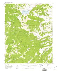 1958 Panguitch Lake1960 Print · USGSThe high plateaus of Garfield County come alive in the late fifties, when the landscape was a mix of volcanic fields and remote ranger outposts. Local history researchers can trace old ranching features like John Cameron Troughs and geologic landmarks such as Mammoth Cave and Ice Cave.3 unique versions available
 - 1962 Map of Cedar City
 1962 Cedar City1962 Print · USGSSouthern Utah in the early sixties showcases a landscape of dramatic plateaus and historic mining outposts. Trace the early settlement patterns at the Silver Reef (ruins), locate the Iron Mine near the Hurricane Cliffs, or find the Fort Harmony Monument.
 - 1980 Map of Panguitch, 1981 Print
 1980 Panguitch1981 Print · USGSThe high plateau country of Southern Utah is captured here in the early eighties, centered on the Sevier River and the gateway town of Panguitch. Researchers can trace the boundaries of Bryce Canyon National Park and find local landmarks like Ruby's Inn, Panguitch Lake, and Hatch.2 unique versions available
 - 1985 Map of Panguitch Lake
 1985 Panguitch Lake1985 Print · USGSSouthern Utah's high-elevation lake country is captured in the mid-eighties as a hub for forest recreation and ranching. Trace the development of Panguitch Lake and find remote landmarks like John L Flat, Miller Knoll, and Mammoth Spring.2 unique versions available
 - 2002 Map of Panguitch Lake, 2005 Print
 2002 Panguitch Lake2005 Print · USGSHigh-altitude water management and mountain ranching define this portion of the Dixie National Forest at the turn of the century. Researchers can trace the development of Panguitch Lake and locate family landmarks such as Miller Knoll or Cameron Troughs.
 - 2011 Map of Panguitch Lake, 2011 Print
 2011 Panguitch Lake2011 Print · USGSCovers Panguitch Lake Resort, including Iron County, Garfield County, and other nearby areas
 - 2014 Map of Panguitch Lake, 2014 Print
 2014 Panguitch Lake2014 Print · USGSCovers Panguitch Lake Resort, including Iron County, Garfield County, and other nearby areas
 - 2017 Map of Panguitch Lake, 2017 Print
 2017 Panguitch Lake2017 Print · USGSCovers Panguitch Lake Resort, including Iron County, Garfield County, and other nearby areas
 - 2020 Map of Panguitch Lake, 2020 Print
 2020 Panguitch Lake2020 Print · USGSCovers Panguitch Lake Resort, including Iron County, Garfield County, and other nearby areas
 - 2023 Map of Panguitch Lake, 2023 Print
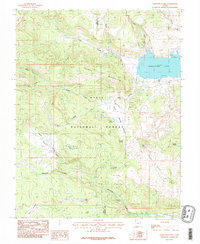
 2023 Panguitch Lake2023 Print · USGSThe high plateau country of Iron and Garfield counties is meticulously detailed here in the early twenty-first century. Researchers can trace the network of forest roads and trails surrounding Panguitch Lake, from Mammoth Spring to the heights of Prince Mtn.
End of results
Showing maps 1-13 of 13
Top cities near Panguitch Lake Resort
- Parowan historical maps
- Panguitch historical maps
- Paragonah historical maps
- Brian Head historical maps
- Hatch historical maps
Frequently asked questions
- What are the different types of historical maps available for Panguitch Lake Resort?
- What is the oldest map of Panguitch Lake Resort?
- Where can I purchase historical maps of Panguitch Lake Resort for my home or office?
- Where can I download high-res historical maps of Panguitch Lake Resort?
- Are there historical topographic maps available for Panguitch Lake Resort?
- Is there historical aerial imagery available for Panguitch Lake Resort?
- Where are historical maps of Panguitch Lake Resort sourced from?