1980s Maps of Westwater, Utah
Explore 2 historic maps of Westwater from the 1980s. These maps offer a rare glimpse into what life looked like during the 1980s — showing old roads, neighborhoods, homes, and landmarks that have changed or disappeared over time.
Whether you're researching your family's past, planning a metal detecting trip, or studying how Westwater's landscape evolved across the 1980s, these high-resolution maps are a powerful tool for exploring the history of this region.
- Focus on a specific era: All maps on this page are from the 1980s, giving you a focused view of this time period.
- See what’s changed: Compare century-old streets, trails, and buildings to today's modern landscape using overlays and satellite layers.
- Research with precision: Use these maps for genealogy, historical research, land use analysis, or educational projects.
- View, download, or print: Maps are fully viewable online in high resolution, and can be downloaded or printed for your own records.
Start exploring Westwater's history through authentic maps from the 1980s. This is your window into the past.
Westwater, UT maps
(2)- 1980 Map of Westwater, 1987 Print
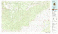 1980 Westwater1987 Print · USGSGrand County, Utah, and western Colorado are captured here in the early 1980s as a landscape of deep canyons and energy extraction. Trace the path of the Denver and Rio Grande Western Railroad or locate landmarks like Westwater Creek and the Cisco Dome Oil Field.2 unique versions available
 - 1985 Map of Westwater, 1986 Print
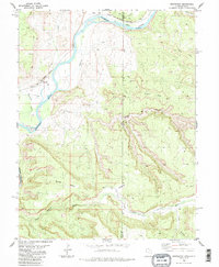 1985 Westwater1986 Print · USGSThe Utah-Colorado borderlands come into focus in the mid-1980s as the river and rail corridor winds through high desert plateaus. Researchers can trace the path of the Denver and Rio Grande Western through Ruby Canyon and locate remote outposts like Westwater and Utaline.2 unique versions available
End of results
Showing maps 1-2 of 2
Frequently asked questions
- What are the different types of historical maps available for Westwater?
- What is the oldest map of Westwater?
- Where can I purchase historical maps of Westwater for my home or office?
- Where can I download high-res historical maps of Westwater?
- Are there historical topographic maps available for Westwater?
- Is there historical aerial imagery available for Westwater?
- Where are historical maps of Westwater sourced from?