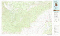
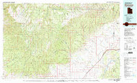
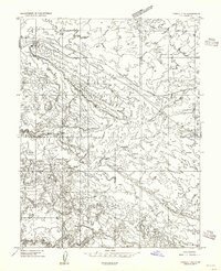
1980 Map of Westwater
USGS Topo · Published 1987About this map
The Roan Cliffs and Book Cliffs dominate this 1980s landscape, marking the dramatic transition from the high Tavaputs Plateau to the sweeping Grand Valley. This remote desert environment is bisected by the powerful course of the Colorado River, joined in the southeast by the Dolores River. The map reveals an industrial layer of resource extraction, with the Cisco Dome Oil Field and San Arroyo Gas Field indicating the region's energy importance during the late twentieth century.
Find a feature on this map
26 named features on this map. Tap any name to fly to it.
Don’t see what you’re looking for? This feature index may not catch every label — zoom into the map to look around manually.
Map Details
Editions of this 1980 Westwater Map
2 editions found
Other maps of this area

1885 · San Rafael
USGS Topo · 1:250,000

1885 · East Tavaputs
USGS Topo · 1:250,000

1885 · La Sal
USGS Topo · 1:250,000

1886 · Price River
USGS Topo · 1:250,000

1896 · Price River
USGS Topo · 1:250,000
1953 · Firewater Canyon
USGS Topo · 1:62,500
1954 · Westwater 4 SW
USGS Topo · 1:24,000
1954 · Tidwell 1 NE
USGS Topo · 1:24,000
1954 · Flat Canyon
USGS Topo · 1:62,500
1954 · Mt. Waas 1 NE
USGS Topo · 1:24,000