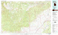
1980 Map of Westwater
USGS Topo · Published 1987About this map
The Tavaputs Plateau and the sheer verticality of the Roan Cliffs dominate this rugged 1980 study of the Utah-Colorado borderlands. This landscape is defined by its dramatic geological transitions, where the high tablelands of the East Tavaputs Plateau drop toward the Grand Valley floor. In the lower elevations, the Colorado River and Dolores River carve through the sandstone, creating a corridor for the Denver and Rio Grande Western Railroad. Resource extraction is a primary feature of the region, evidenced by the Cisco Dome Oil Field and San Arroyo Gas Field, as well as the Crescent Mine. The map also details the southeastern extent of the Uintah and Ouray Indian Reservation, highlighting the intersection of tribal lands, state boundaries, and industrial development in the high desert.
Find a feature on this map
33 named features on this map. Tap any name to fly to it.
Don’t see what you’re looking for? This feature index may not catch every label — zoom into the map to look around manually.
Map Details
Editions of this 1980 Westwater Map
2 editions found
Other maps of this area

1885 · San Rafael
USGS Topo · 1:250,000

1885 · East Tavaputs
USGS Topo · 1:250,000

1885 · La Sal
USGS Topo · 1:250,000

1886 · Price River
USGS Topo · 1:250,000

1896 · Price River
USGS Topo · 1:250,000

1953 · Firewater Canyon
USGS Topo · 1:62,500

1954 · Westwater 4 SW
USGS Topo · 1:24,000

1954 · Tidwell 1 NE
USGS Topo · 1:24,000

1954 · Flat Canyon
USGS Topo · 1:62,500

1954 · Mt. Waas 1 NE
USGS Topo · 1:24,000