Old Maps of Duck Creek Village, Utah for Hiking & Exploration
Hike through history with 13 historic maps of Duck Creek Village. Explore old trails, ghost towns, and forgotten backroads — perfect for outdoor adventurers and local explorers.
- Rediscover forgotten places: Map out old mining camps, roads, and footpaths that no longer exist on modern maps.
- Layer with modern tools: Combine with LiDAR or satellite views to plan hikes through historical terrain.
- Made for exploration: Popular among hikers, overlanders, and local history lovers.
Use these maps to find adventure and explore the hidden past of Duck Creek Village.
Duck Creek Village, UT maps
(13)- 1886 Map of Kanab
 1886 Kanab1886 Print · USGSSouthern Utah in the late nineteenth century remains a frontier of deep canyons and high plateaus. Researchers can trace early pioneer outposts and river settlements like Orderville, Mt. Carmel, and Kanab tucked beneath the Vermilion Cliffs.5 unique versions available
 - 1953 Map of Cedar City, 1966 Print
 1953 Cedar City1966 Print · USGSSouthwestern Utah's high plateaus and desert basins are mapped here during the mid-fifties, showing the region before the modern interstate system. Researchers can trace historic mining at Silver Reef, follow the Union Pacific line, and locate early settlements like Kanarraville and Toquerville.3 unique versions available
 - 1958 Map of Cedar City
 1958 Cedar City1958 Print · USGSSouthwestern Utah in the late fifties was a land of mineral extraction and monumental landscapes. Genealogists and historians can trace pioneer-era settlements like Grafton and Parowan alongside industrial sites such as the Silver Reef Mine.2 unique versions available
 - 1958 Map of Panguitch Lake, 1960 Print
 1958 Panguitch Lake1960 Print · USGSThe high plateaus of Garfield County come alive in the late fifties, when the landscape was a mix of volcanic fields and remote ranger outposts. Local history researchers can trace old ranching features like John Cameron Troughs and geologic landmarks such as Mammoth Cave and Ice Cave.3 unique versions available
 - 1962 Map of Cedar City
 1962 Cedar City1962 Print · USGSSouthern Utah in the early sixties showcases a landscape of dramatic plateaus and historic mining outposts. Trace the early settlement patterns at the Silver Reef (ruins), locate the Iron Mine near the Hurricane Cliffs, or find the Fort Harmony Monument.
 - 1980 Map of Panguitch, 1981 Print
 1980 Panguitch1981 Print · USGSThe high plateau country of Southern Utah is captured here in the early eighties, centered on the Sevier River and the gateway town of Panguitch. Researchers can trace the boundaries of Bryce Canyon National Park and find local landmarks like Ruby's Inn, Panguitch Lake, and Hatch.2 unique versions available
 - 1985 Map of Henrie Knolls
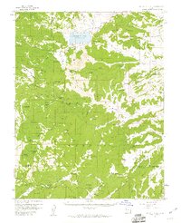
 1985 Henrie Knolls1985 Print · USGSThe high Markagunt Plateau in the mid-1980s is captured here as a landscape of timber and hidden waters. Researchers can trace the unique drainage of Duck Creek Sinks and find seasonal landmarks like Aspen Mirror Lake, Cow Lake, and Bowers Flat.2 unique versions available
 - 2002 Map of Henrie Knolls, 2005 Print
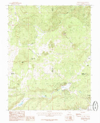
 2002 Henrie Knolls2005 Print · USGSThe Markagunt Plateau at the turn of the millennium was a hub of forest management and high-country recreation. Map collectors and hikers can trace the Lost Hunter Trail, locate the Duck Creek Work Center, and study the unique Duck Creek Sinks.
 - 2011 Map of Henrie Knolls, 2011 Print
 2011 Henrie Knolls2011 Print · USGSCovers Duck Creek Village, including Iron County, Kane County, and other nearby areas
 - 2014 Map of Henrie Knolls, 2014 Print
 2014 Henrie Knolls2014 Print · USGSCovers Duck Creek Village, including Iron County, Kane County, and other nearby areas
 - 2017 Map of Henrie Knolls, 2017 Print
 2017 Henrie Knolls2017 Print · USGSCovers Duck Creek Village, including Iron County, Kane County, and other nearby areas
 - 2020 Map of Henrie Knolls, 2020 Print
 2020 Henrie Knolls2020 Print · USGSCovers Duck Creek Village, including Iron County, Kane County, and other nearby areas
 - 2023 Map of Henrie Knolls, 2023 Print
 2023 Henrie Knolls2023 Print · USGSHigh mountain plateaus and forest retreats come into focus on this recent map of the Dixie National Forest boundary. Explore the road and trail networks surrounding Duck Creek Village, the High Meadow Ranch Airport, and the geologic Duck Creek Sinks.
End of results
Showing maps 1-13 of 13
Top cities near Duck Creek Village
Frequently asked questions
- What are the different types of historical maps available for Duck Creek Village?
- What is the oldest map of Duck Creek Village?
- Where can I purchase historical maps of Duck Creek Village for my home or office?
- Where can I download high-res historical maps of Duck Creek Village?
- Are there historical topographic maps available for Duck Creek Village?
- Is there historical aerial imagery available for Duck Creek Village?
- Where are historical maps of Duck Creek Village sourced from?