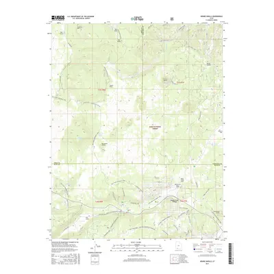
2017 Map of Henrie Knolls
USGS Topo · Published 2017About this map
Duck Creek Village serves as a central hub on the Markagunt Plateau in this 2017 survey of the high-elevation terrain where Iron, Garfield, and Kane counties meet. The landscape is defined by a series of volcanic and limestone features, most notably the Duck Creek Sinks where water disappears into the subterranean drainage system of the plateau. High-altitude meadows and valleys like Sage Valley and Tippets Valley are framed by prominent heights such as Houston Mtn and the namesake Henrie Knolls.
Find a feature on this map
59 named features on this map. Tap any name to fly to it.
Don’t see what you’re looking for? This feature index may not catch every label — zoom into the map to look around manually.
Map Details
Editions of this 2017 Henrie Knolls Map
This is the sole edition of this map. No revisions or reprints were ever made.
Other maps of this area

1886 · Kanab
USGS Topo · 1:250,000

1953 · Cedar City
USGS Topo · 1:250,000

1957 · Orderville Canyon NE
USGS Topo · 1:24,000

1958 · Cedar City
USGS Topo · 1:250,000

1958 · Orderville
USGS Topo · 1:62,500

1958 · Cedar Breaks
USGS Topo · 1:62,500

1958 · Panguitch Lake
USGS Topo · 1:62,500

1962 · Cedar City
USGS Topo · 1:250,000
1980 · Straight Canyon
USGS Topo · 1:24,000

1980 · Panguitch
USGS Topo · 1:100,000