1950s Maps of Paria, Utah
Explore 3 historic maps of Paria from the 1950s. These maps offer a rare glimpse into what life looked like during the 1950s — showing old roads, neighborhoods, homes, and landmarks that have changed or disappeared over time.
Whether you're researching your family's past, planning a metal detecting trip, or studying how Paria's landscape evolved across the 1950s, these high-resolution maps are a powerful tool for exploring the history of this region.
- Focus on a specific era: All maps on this page are from the 1950s, giving you a focused view of this time period.
- See what’s changed: Compare century-old streets, trails, and buildings to today's modern landscape using overlays and satellite layers.
- Research with precision: Use these maps for genealogy, historical research, land use analysis, or educational projects.
- View, download, or print: Maps are fully viewable online in high resolution, and can be downloaded or printed for your own records.
Start exploring Paria's history through authentic maps from the 1950s. This is your window into the past.
Paria, UT maps
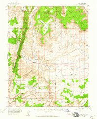
(3)- 1954 Map of Paria NW, 1956 Print
 1954 Paria NW1956 Print · USGSThe high desert of Kane County is captured in the mid-fifties, dominated by the striking geologic uplift of The Cockscomb. Genealogists and historians can locate a remote Cemetery and trace the original water routes of the Paria River and Cottonwood Creek.
 - 1954 Map of Paria, 1959 Print
 1954 Paria1959 Print · USGSThe Kane County high desert is captured here in the mid-1950s, showing the intersection of Utah and Arizona along the Salt Lake Meridian. Genealogists and historians can locate the Paria townsite, the Cem, and several ranching or mining remnants like Adairville and Johnson Store.2 unique versions available
 - 1956 Map of Escalante
 1956 Escalante1956 Print · USGSSouthern Utah and Northern Arizona are charted here in the mid-fifties, just before the canyon floor was transformed. Researchers can trace remote desert commerce at Oljeto Trading Post, find the Adairville (ruins), and locate Uranium mines.5 unique versions available
End of results
Showing maps 1-3 of 3
Frequently asked questions
- What are the different types of historical maps available for Paria?
- What is the oldest map of Paria?
- Where can I purchase historical maps of Paria for my home or office?
- Where can I download high-res historical maps of Paria?
- Are there historical topographic maps available for Paria?
- Is there historical aerial imagery available for Paria?
- Where are historical maps of Paria sourced from?