
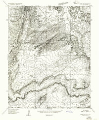
1954 Map of Paria NW
USGS Topo · Published 1956About this map
The Cockscomb dominates this mid-1950s terrain in Kane County, appearing as a dramatic vertical uplift that separates the lower drainages from the massive heights of the Kaiparowits Plateau. The drainage of the Paria River snakes through the center of the sheet, supported by tributaries like Cottonwood Creek and Sand Gulch. This preliminary survey highlights early attempts at water management in a desert environment, evidenced by a Reservoir and a supporting Ditch near the riverbanks. Local history is anchored by a lone Cemetery in the northern reach and the presence of Fivemile Mountain to the west. The survey also preserves important geodetic markers of the era, such as the Township Corner VABM 4879, used to define boundaries across the West Cove landscape before more modern surveying techniques were implemented.
Find a feature on this map
12 named features on this map. Tap any name to fly to it.
Don’t see what you’re looking for? This feature index may not catch every label — zoom into the map to look around manually.
Map Details
Editions of this 1954 Paria NW Map
This is the sole edition of this map. No revisions or reprints were ever made.
Other maps of this area

1886 · Kanab
USGS Topo · 1:250,000

1886 · Escalante
USGS Topo · 1:250,000

1953 · Cedar City
USGS Topo · 1:250,000

1954 · Buckskin Gulch NE
USGS Topo · 1:24,000

1954 · Buckskin Gulch SE
USGS Topo · 1:24,000
1954 · Paria SW
USGS Topo · 1:24,000

1954 · Buckskin Gulch
USGS Topo · 1:62,500

1954 · Paria
USGS Topo · 1:62,500

1955 · The Cockscob SW
USGS Topo · 1:24,000

1956 · Escalante
USGS Topo · 1:250,000