
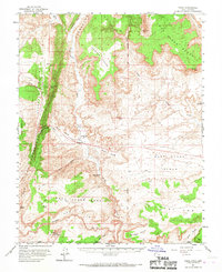
1954 Map of Paria
USGS Topo · Published 1959About this map
Paria stands as the primary namesake settlement on this mid-century survey of the Kane County borderlands, situated where Cottonwood Creek meets the Paria River. The landscape is dominated by the striking linear formation of The Cockscomb, which separates Five Mile Valley from the expansive Brigham Plains. This map captures a remote desert environment punctuated by the remnants of earlier settlement attempts, most notably at Adairville and White House. Evidence of early 20th-century activity is visible through a Cem, a Prospect, and the Johnson Store located near West Cove Gulch. The mapping of a Jeep Trail winding across the West Clark Bench reflects the mid-century transition from pack animal paths to motorized exploration in the high desert of the Colorado Plateau.
Find a feature on this map
42 named features on this map. Tap any name to fly to it.
Don’t see what you’re looking for? This feature index may not catch every label — zoom into the map to look around manually.
Map Details
Editions of this 1954 Paria Map
2 editions found
Other maps of this area

1886 · Kanab
USGS Topo · 1:250,000

1886 · Escalante
USGS Topo · 1:250,000

1886 · Echo Cliffs
USGS Topo · 1:250,000

1886 · Kaibab
USGS Topo · 1:250,000

1891 · Echo Cliffs
USGS Topo · 1:250,000

1922 · Upper Last Chance
USGS Topo · 1:63,360

1953 · Nipple Butte
USGS Topo · 1:62,500

1953 · Cedar City
USGS Topo · 1:250,000

1953 · Grand Canyon
USGS Topo · 1:250,000

1954 · Buckskin Gulch NE
USGS Topo · 1:24,000