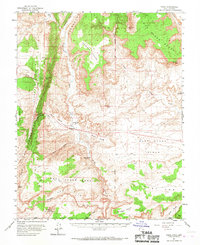
1954 Map of Paria
USGS Topo · Published 1967About this map
Paria and the surrounding high desert canyon country of Kane County are documented here in the mid-1950s, a period when this remote segment of the Salt Lake Meridian remained largely defined by early ranching outposts and remnants of pioneer activity. The mapping shows the transition of the Paria River as it carves through dramatic geological formations like The Cockscomb and Brigham Plains. This survey is particularly valuable for documenting the sites of Adairville and White House, alongside the Johnson Store, reflecting the difficult history of settlement in this arid landscape. Historical land use is further evidenced by a Prospect and a cemetery near the northern settlement, while the network of primitive transport is marked by several stretches of Jeep Trail and a localized Tunnel. Water sources, critical for survival in this terrain, are carefully noted at Pigeon Spring and various tanks across the East Clark Bench.
Find a feature on this map
45 named features on this map. Tap any name to fly to it.
Don’t see what you’re looking for? This feature index may not catch every label — zoom into the map to look around manually.
Map Details
Editions of this 1954 Paria Map
2 editions found

Other maps of this area

1886 · Kanab
USGS Topo · 1:250,000

1886 · Escalante
USGS Topo · 1:250,000

1886 · Echo Cliffs
USGS Topo · 1:250,000

1886 · Kaibab
USGS Topo · 1:250,000

1891 · Echo Cliffs
USGS Topo · 1:250,000

1922 · Upper Last Chance
USGS Topo · 1:63,360

1953 · Nipple Butte
USGS Topo · 1:62,500

1953 · Cedar City
USGS Topo · 1:250,000

1953 · Grand Canyon
USGS Topo · 1:250,000

1954 · Buckskin Gulch NE
USGS Topo · 1:24,000