1970s Maps of Magna, Utah
Explore 4 historic maps of Magna from the 1970s. These maps offer a rare glimpse into what life looked like during the 1970s — showing old roads, neighborhoods, homes, and landmarks that have changed or disappeared over time.
Whether you're researching your family's past, planning a metal detecting trip, or studying how Magna's landscape evolved across the 1970s, these high-resolution maps are a powerful tool for exploring the history of this region.
- Focus on a specific era: All maps on this page are from the 1970s, giving you a focused view of this time period.
- See what’s changed: Compare century-old streets, trails, and buildings to today's modern landscape using overlays and satellite layers.
- Research with precision: Use these maps for genealogy, historical research, land use analysis, or educational projects.
- View, download, or print: Maps are fully viewable online in high resolution, and can be downloaded or printed for your own records.
Start exploring Magna's history through authentic maps from the 1970s. This is your window into the past.
Magna, UT maps
(4)- 1972 Map of Antelope Island South, 1974 Print
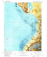 1972 Antelope Island South1974 Print · USGSThe southern shore of the Great Salt Lake in the early seventies shows a landscape shaped by salt production and recreation. Trace the footprint of the Saltair Resort (Site) and follow the Salt Lake Garfield and Western line across the mud flats.2 unique versions available
 - 1972 Map of Farnsworth Peak, 1974 Print
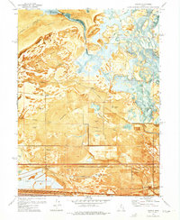
 1972 Farnsworth Peak1974 Print · USGSThe industrial shoreline of the Salt Lake Valley meets the high Oquirrh peaks in the early seventies, capturing a landscape of massive mines and vital rail corridors. Researchers can trace the legacy of the Garfield townsite, the sprawling tailings ponds, and the operations at Arthur and Lake Point.4 unique versions available
 - 1972 Map of Saltair, 1975 Print
 1972 Saltair1975 Print · USGSThe salt flats and wetlands west of Salt Lake City are captured here in the early seventies during a period of industrial and recreational expansion. Genealogists and researchers can trace rail history and waterfowl culture through the Salt Evaporators, Lake Front Duck Club, and the depot at Riter.4 unique versions available
 - 1979 Map of Tooele, 1980 Print
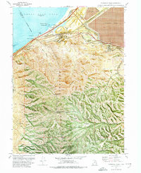
 1979 Tooele1980 Print · USGSTooele and the eastern Oquirrh foothills appear here in the late seventies, showing a landscape defined by massive industrial works and military sites. Researchers can trace the rail corridors of the Western Pacific or locate the historic Monarch Mine and the vast Open Pit Mine near Bingham.
End of results
Showing maps 1-4 of 4
Top cities near Magna
- Salt Lake City historical maps
- West Valley City historical maps
- West Jordan historical maps
- South Jordan historical maps
- Taylorsville historical maps
- Herriman historical maps
See more
Top neighborhoods of Magna
Frequently asked questions
- What are the different types of historical maps available for Magna?
- What is the oldest map of Magna?
- Where can I purchase historical maps of Magna for my home or office?
- Where can I download high-res historical maps of Magna?
- Are there historical topographic maps available for Magna?
- Is there historical aerial imagery available for Magna?
- Where are historical maps of Magna sourced from?