1960s Maps of Redmond, Utah
Explore 8 historic maps of Redmond from the 1960s. These maps offer a rare glimpse into what life looked like during the 1960s — showing old roads, neighborhoods, homes, and landmarks that have changed or disappeared over time.
Whether you're researching your family's past, planning a metal detecting trip, or studying how Redmond's landscape evolved across the 1960s, these high-resolution maps are a powerful tool for exploring the history of this region.
- Focus on a specific era: All maps on this page are from the 1960s, giving you a focused view of this time period.
- See what’s changed: Compare century-old streets, trails, and buildings to today's modern landscape using overlays and satellite layers.
- Research with precision: Use these maps for genealogy, historical research, land use analysis, or educational projects.
- View, download, or print: Maps are fully viewable online in high resolution, and can be downloaded or printed for your own records.
Start exploring Redmond's history through authentic maps from the 1960s. This is your window into the past.
Redmond, UT maps
(8)- 1960 Map of Price
 1960 Price1960 Print · USGSCentral Utah in the late fifties was a landscape of coal-hauling railroads and high plateau settlements. Genealogists and local historians can trace the rail-to-river economy from Price to the mountain mining camps of Hiawatha, Dragerton, and Sunnyside.2 unique versions available
 - 1960 Map of Salina
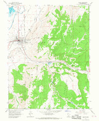
 1960 Salina1960 Print · USGSThe high plateaus and canyonlands of south-central Utah appear in the early sixties as a region of remote ranching towns and developing parklands. Researchers can trace historic settlements like Fruita and Loa or locate the uranium mines and the tracks of the Denver and Rio Grande Western RR.2 unique versions available
 - 1962 Map of Salina
 1962 Salina1962 Print · USGSSevier County and the surrounding desert wilderness appear here in the early sixties as a network of isolated river valley towns and high-altitude forests. Researchers can locate remote landmarks like Fruita, trace the Denver & Rio Grande Western RR, and find backcountry sites like the Aquarius Ranger Station.
 - 1962 Map of Price
 1962 Price1962 Print · USGSCentral Utah during the early sixties shows a landscape balancing high-mountain forestry with valley agriculture and coal mining. Genealogists and historians can trace the Denver and Rio Grande Western rail lines through industrial hubs like Price or locate formerly active sites like Coal City (abandoned).
 - 1966 Map of Redmond Canyon, 1967 Print
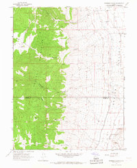 1966 Redmond Canyon1967 Print · USGSCentral Utah's agricultural and mining landscape is documented here in the mid-1960s, showing where the mountains meet the valley. Trace the Old Indian Treaty Boundary or locate early water works like the Piute Canal and Little Ditch.
 - 1966 Map of Redmond, 1967 Print
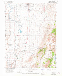 1966 Redmond1967 Print · USGSIn the mid-1960s, the Sevier River valley was a landscape of rail-connected settlements and complex irrigation. Genealogists and historians can trace the Old Indian Treaty Boundary and locate family landmarks like Axtell Cem or the industrial Lime Kiln.2 unique versions available
 - 1966 Map of Salina, 1968 Print
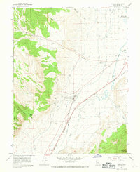
 1966 Salina1968 Print · USGSSevier County was a center of rail and river industry in the 1960s, from the valley floor to the forest boundaries. Genealogists and historians can trace the Pioneer Cemetery, follow the Old Railroad Grade, and locate the old Stone Quarry.2 unique versions available
 - 1966 Map of Aurora, 1969 Print
 1966 Aurora1969 Print · USGSAurora and the Sevier River valley are captured in the mid-1960s, showing a landscape defined by irrigation and rail. Genealogists and historians can trace the town's local Cem, the path of the Denver and Rio Grande Western railroad, and several Gravel Pits.2 unique versions available
End of results
Showing maps 1-8 of 8
Top cities near Redmond
- Richfield historical maps
- Gunnison historical maps
- Salina historical maps
- Centerfield historical maps
- Aurora historical maps
- Sigurd historical maps
See more
Frequently asked questions
- What are the different types of historical maps available for Redmond?
- What is the oldest map of Redmond?
- Where can I purchase historical maps of Redmond for my home or office?
- Where can I download high-res historical maps of Redmond?
- Are there historical topographic maps available for Redmond?
- Is there historical aerial imagery available for Redmond?
- Where are historical maps of Redmond sourced from?